Stratospheric balloons are finally having their moment. All it took was a diplomatic row of global proportions started by one slowly floating spy balloon, and now high-altitude balloons are firmly on everyone’s radar–both figuratively and literally.
But if a geopolitical hullabaloo(n?) is what sparked our collective interest, discovering how these vessels will impact our daily lives is what will sustain it.
The past decade has seen suborbital balloons quietly pioneer a new methodology for collecting data about our rapidly changing world that traditional observation modalities (satellites, airplanes, and drones) are unable to match. This has positioned balloon companies as disruptors in the burgeoning aerial imaging industry, which has become mission critical to the insurance, real estate, and construction industries (among others), and is expected to reach $4.6bn in value by 2025.
This primer offers a bird’s eye view on why many now view balloons as the preeminent option for advancing our understanding of life on the ground (and potentially everywhere in between).
The excitement surrounding stratospheric balloons can be divided into two parts. The first part involves their nimble and efficient operating capabilities:
1) Nimble Operating Capabilities…
- Made of accessible, lightweight, low-cost materials: Balloons are typically made of latex or polyethylene, are often as thin as plastic sandwich bags, and also can be biodegradable. This gives balloon companies an immediate operating advantage over legacy observation modalities (satellites, airplanes, and drones) financially, in terms of flight flexibility, and also in environmental impact.
- No Fuel Required: Balloons have no engine and thus don’t require fuel. Instead, they are powered by highly accessible helium, the same gas used to fill party balloons. This allows balloons to remain airborne for sometimes weeks at a time, making their data capture abilities more robust than fixed-wing aircraft (drones or airplanes), which rely on fuel. Furthermore, complete zero-emission flights makes balloon operations more sustainable than all other legacy modalities.
- Speed to Launch: As a result of the two aforementioned points, flights can launch in a matter of minutes from any location accessible by a pickup truck (used to haul the balloon and aerial imaging payload). Furthermore, while working with the FAA is important, the stratospheric cruising altitude currently enables balloons to operate with less rigidity than airplanes and drones.
- Versatile Flight Options: Balloons can hover over a single location (like a helicopter), provide a slow and stable moving platform (like a drone), or travel great distances over weeks by taking advantage of the stratosphere’s tiered winds (like a sailboat). This flight flexibility offers unrivaled data capture capabilities.
- Rapidly Scalable Process: In addition, most balloon systems and payloads are recoverable, reusable, or can be easily upgraded before the next flight, which can happen quickly. No more legacy hardware floating around in space. No more long lead-times to get images refreshed in rural areas that are far from an airport. The ability to get balloons in the air quickly and capture high fidelity imagery over great distances can’t be matched by any other modality.
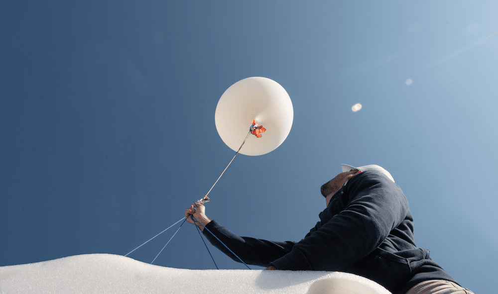
Near Space Labs team member preparing the Swifty for launch.
The second part of the value proposition has to do with the data these balloons deliver, which is highly valuable for three reasons:
2) …That Deliver High-Resolution Terrestrial Imagery
- Ultra High-Resolution Imagery: The data capture capabilities of commercial use balloons has drastically improved in recent years, and can now deliver high fidelity images with 10 cm per pixel resolution. This resolution is a major upgrade from satellites that typically offer 30 cm imagery at best (the higher width, the lower the resolution), and is on par with aerial imaging from airplanes.
- Image Recency: In addition to ultra high-resolution, image recency is an important factor. If change is the only constant in life, then there are countless circumstances in which a high fidelity image that’s over a year old is nowhere near as useful as the same image from a few months, weeks, or even days ago. In many cases, the ability to detect terrestrial changes requires the ability to collect high-resolution images on a frequent cadence. And as seen above, balloons provide a cost effective way to deliver fresh visuals as close to when companies need them most.
- Superior Terrestrial Coverage: Companies, municipalities, and NGOs that require imaging data to understand terrestrial changes often have competing needs. In some cases, they need to observe changes to highly specific locations (e.g. a roof on one specific home), and other times they need to see broader territorial swaths (such as acres of wildfire). In each of these cases, balloons provide the best solution due to their highly flexible operating capabilities, their ability to cover and capture high-resolution images over great distances, and their ability to repeat this process at scale.
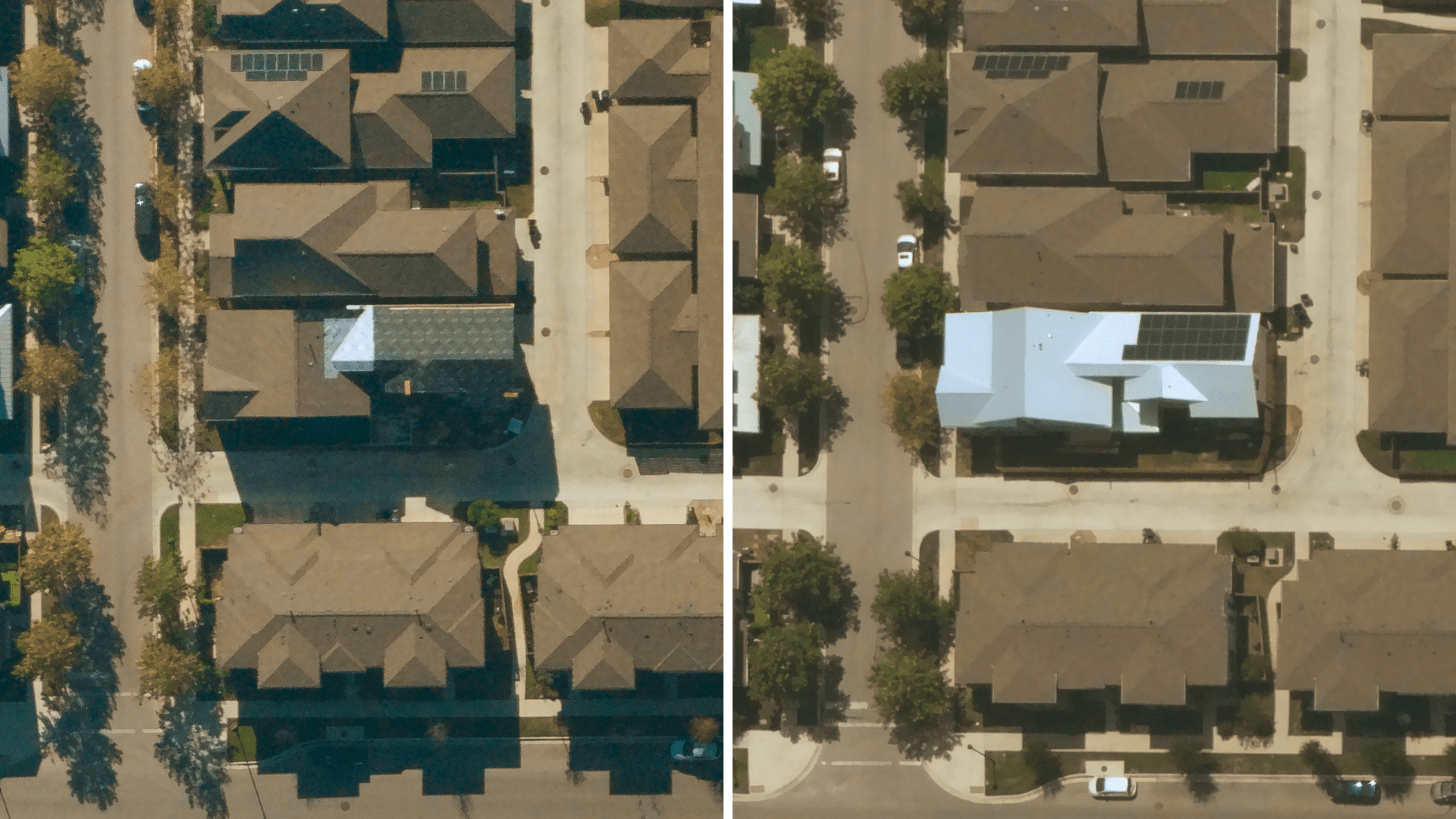
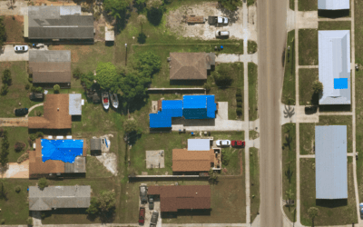
Near Space Labs’ 10 cm imagery showcasing updates to a property’s roof in Austin, Texas.
The next section offers insights into how balloons actually fly.
How and Where Balloons Fly:
- How They Ascend: The balloon is partially filled with helium and launched with the payload section suspended beneath it. As the balloon rises, the helium expands, filling the balloon until it reaches desired altitude. This can take between 15 minutes to 1 hour depending on the size of the balloon and the weight of the payload.
- Altitude Capabilities: Stratospheric balloons can operate at an altitude between 20 and 60 km (28 miles). This altitude–known as “near space”–is above 99% of our atmosphere, and offers both sweeping panoramas of Earth as well as clear views into space. And yet, the range is only inhabitable by these vessels, as it remains too low for satellites and too high for fixed wing aircraft.
- Flight Duration Capabilities: A typical balloon flight duration varies from a few hours to several weeks, depending on the balloon type, the payload, the launch site and flight trajectory.
- Payload Capabilities: The largest balloons can manage payloads weighing up as much as 3,600 kilograms (8,000 pounds), roughly equivalent to three small cars.
- How They Land: After the mission is complete, flight controllers send a radio command that separates the payload from the balloon. The payload floats back to the ground on a parachute where it can be retrieved and flown again. Payload separation creates a large tear in the balloon material, which releases any remaining helium. The balloon also falls to the ground, where it is retrieved.
The following section compares balloons with legacy image capture modalities.
How Balloons Compare with Satellites:
- Lower Cost: Satellites can cover huge swaths of the planet but remain expensive to develop, launch, and operate. Balloons can be launched quickly and used to test and advance both Earth imaging and space science for up to 40x less cost than satellites.
- Flight Versatility: Satellites follow a known orbit, which can be limiting when a weather pattern is blocking the view of a desired location when a satellite is traveling over it. Balloons might experience the same weather pattern, but can idle above it for long periods of time, giving the best opportunity to capture the desired imagery when the weather passes.
- Image Resolution: Satellite cameras are also hundreds of kilometers from the things they are trying to see, and often moving at tens of thousands of kilometers per hour. For this reason, 30 cm is a standard resolution offering. The fact that balloons operate in the stratosphere already gives them a proximity advantage over satellites. This advantage translates into 10 cm resolution imagery, which delivers much greater detail and opportunity to diagnose change on the ground.
How Balloons Compare with Airplanes:
- Reaction Speed: It is common for the FAA to designate no fly zones in areas suffering from a recent catastrophe. This standard procedure gives balloons an advantage in their ability to capture and deliver post-catastrophe imaging faster than airplanes by flying and operating well above commercial airspace.
- Lower Cost: With no fuel requirements, as well as other lower operating costs, balloons again offer an advantage over airplanes.
- Coverage Areas: The cost structure of fixed-wing aircraft also limits their ability to easily, and repeatedly cover more rural areas. This leaves enormous coverage gaps which expose their customers to the risk of outdated data, if they were able to attain any data at all.
- Environmentally Friendly: Zero fuel = zero emissions. Enough said.
How Balloons Compare with Drones:
- Coverage Areas: Drones can certainly take super sharp images, but only over a relatively small area (up to 10 kilometers), and regulations often prevent them from flying over major cities. Also, each drone requires careful human piloting to ensure proper imaging outcomes. Balloons modestly trade off image resolution versus drones, but can deliver images from an area up to 100x the size of what drones can cover.
- Reaction Speed: Restrictions again play a role in when, where, and how quickly drones can fly. Like planes, drones are subject to no-fly rules immediately after a catastrophe. This, along with their limited coverage distance, and the fact that they’re often unable to fly over major cities, severely limits their use cases compared to balloons.
Final Thoughts:
Stratospheric balloons are a next generation high-quality imaging solution that’s driven by unrivaled operating capabilities. Any business that depends on terrestrial assessment should investigate balloon-based imagery as an alternative to legacy solutions. Those that do will find the ROI to be out of this world.
Attribution:
This article is a contribution from Delauno Hinson, a Strategic Account leader at Near Space Labs. Delauno specializes in working with our insurance customers to improve their intelligence gathering and decisioning processes. In his free time, Delauno enjoys spending time with his family and playing make believe with his three young kids.