Are you ready for hurricane season to not feel like an all-hands-on-deck time of year? Near Space Labs helps claims teams proactively prepare for an influx in claims during storm season so they can help policyholders faster and reduce the likelihood of repeated claims losses.
Here’s how:
1. Pre-catastrophe imagery
To truly validate a claim, visual insights of the property before the claim is just as important as after. Why? Without access to readily available, frequently updated pre-CAT imagery, carriers may be exposed to higher risks of fraud, losses due to overpayment, and spiked litigation expenses.
Near Space Labs’ pre-hurricane imagery serves as indisputable evidence of residential and commercial property conditions prior to claims. Our data is updated every 90 days, ensuring claims teams only reference the most recent and accurate information available to authenticate claims, determine equitable payout amounts, and quickly support customers in their time of urgency.
With details such as cracked roofs, missing shingles, and water damages easily visible, the accuracy of damage assessments are also improved. Furthermore, pre-CAT imagery can be leveraged to provide a clear visual representation to customers regarding payout calculations in order to effectively mitigate the potential of litigation.
Most importantly, maintaining up-to-date pre-CAT data is imperative in order to prevent claims teams from encountering the very inaccuracies and losses they aim to avoid. With our solution, changes across all four seasons are accounted for, cementing the data’s reliability and empowering trust in the data driving decisions.
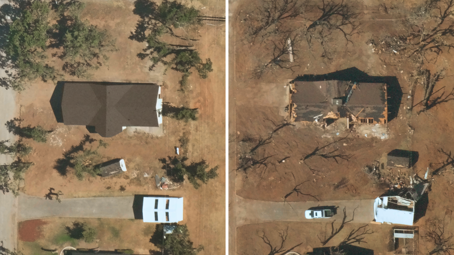
Near Space Labs’ pre-catastrophe (left) and post-catastrophe (right) imagery, aiding insurers in claim validation and highly accurate damage assessments.
2. Timely post-catastrophe imagery
We understand the urgency for carriers and policyholders after a severe storm. That’s why we built our earth imaging technology to be designed for rapid response. Following catastrophic events, such as hurricanes, Near Space Labs provides imagery to claims teams as little as 8 hours from the commencement of image capture. While traditional methods such as airplanes may need to wait for flight approvals and altitude regulations to clear, our light-weight and mobile balloon technology allows us to launch at the first sight of breaking clouds, enabling us to get in the air faster, capture data quickly, and promptly provide carriers with the insights they need to begin the settlement process as soon as possible.
We are also able to cover more geographies in less time. Airplanes often lack coverage of rural and remote areas – which often get hit by hurricanes as hard as urban areas – leaving insurers to resort to other methods such as waiting for on-site assessments which could dramatically halt the claims process in underserved areas.
Near Space Labs offers 100% coverage of the contiguous US, including rural, suburban, and urban locations to ensure carriers are quickly and efficiently helping customers across all of their policies.
Our imagery resolution is also comparable with airplanes, allowing assessors to clearly identify the extent of damages and effectively triage on-site visits. In the case of a full loss, the settlement process can begin immediately. In turn, assessors can prioritize partial loss cases with visual direction on exactly where they need to go. This dramatically improves the operational efficiency of damage assessments and accelerates customer service speed.
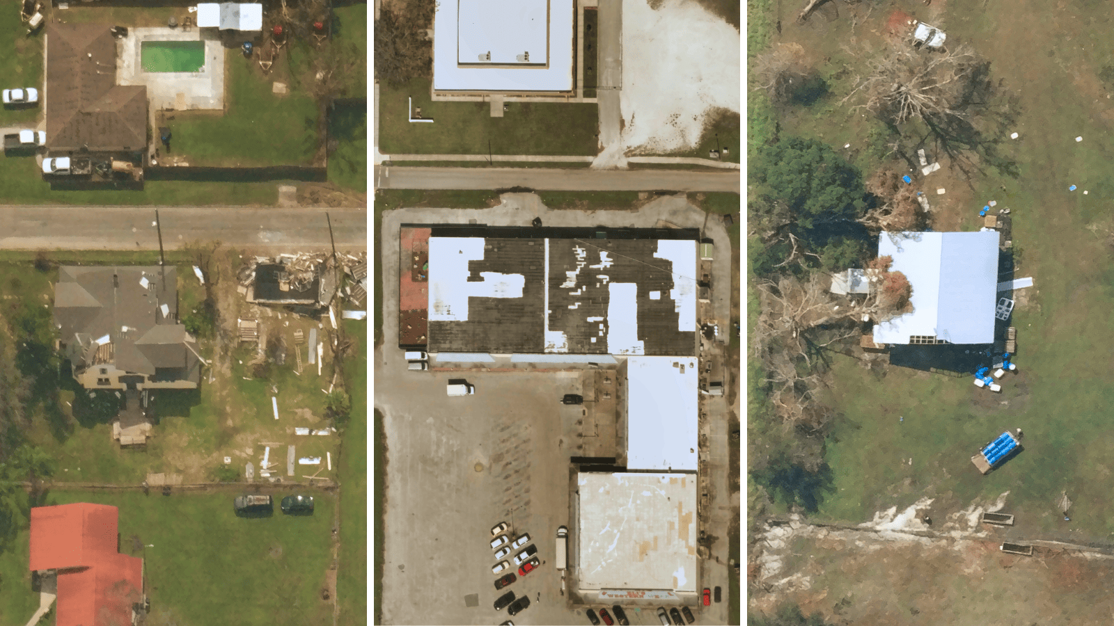
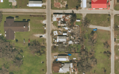
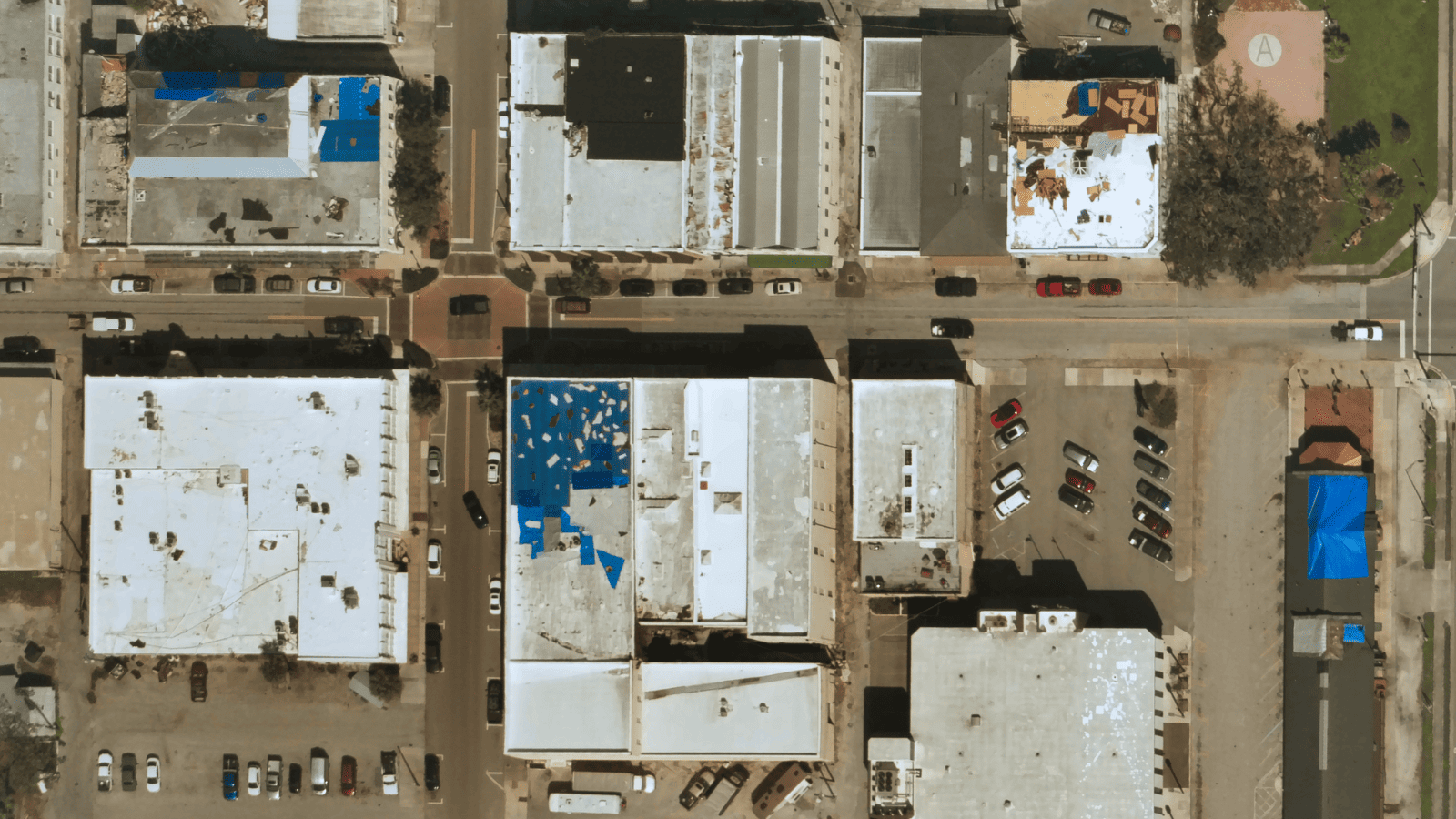
Near Space Labs’ high-resolution images of damaged residential and commercial properties post-hurricane across suburban, urban, and rural areas in Florida.
3. 90-day post-catastrophe recovery imagery
With the escalating frequency and intensity of extreme weather events, properties in high-risk areas are increasingly susceptible to enduring multiple storms and consequently filing numerous claims throughout the year.
This leaves room for policyholders to receive additional claims payouts for pre-existing damages that have already been compensated for. In other words, increased losses for the carrier; And with 2022 seeing the largest net underwriting loss since 2011, insurers need innovative solutions to reverse this trajectory.
Near Space Labs’ post-CAT recovery imagery serves as protection for the carrier. We provide continuous recaptures of affected areas which allows claims teams to monitor the recovery progress of properties and build strategies around how to prevent repeated claims losses. For example, if a carrier sees a property’s roof is still not repaired one month after filing a claim, they can proactively reach out to the policyholder to check on the status, offer assistance, or alert them of the potential consequences if the property is not repaired prior to the next claim.
Near Space Labs’ imagery, captured 90 days post-hurricane, reveals slow recovery progress of damaged commercial buildings indicating potential vulnerability to future storms.
Furthermore, claims teams can present visual evidence of the properties conditions to the policyholder to reduce legal conflicts in the case they find a claim is not valid or find that pre-existing damages are affecting the payout amount.
This added level of insight – after a hurricane has passed and communities have had time to recover – can provide carriers with a new level of protection and insight that has yet to be accessible.
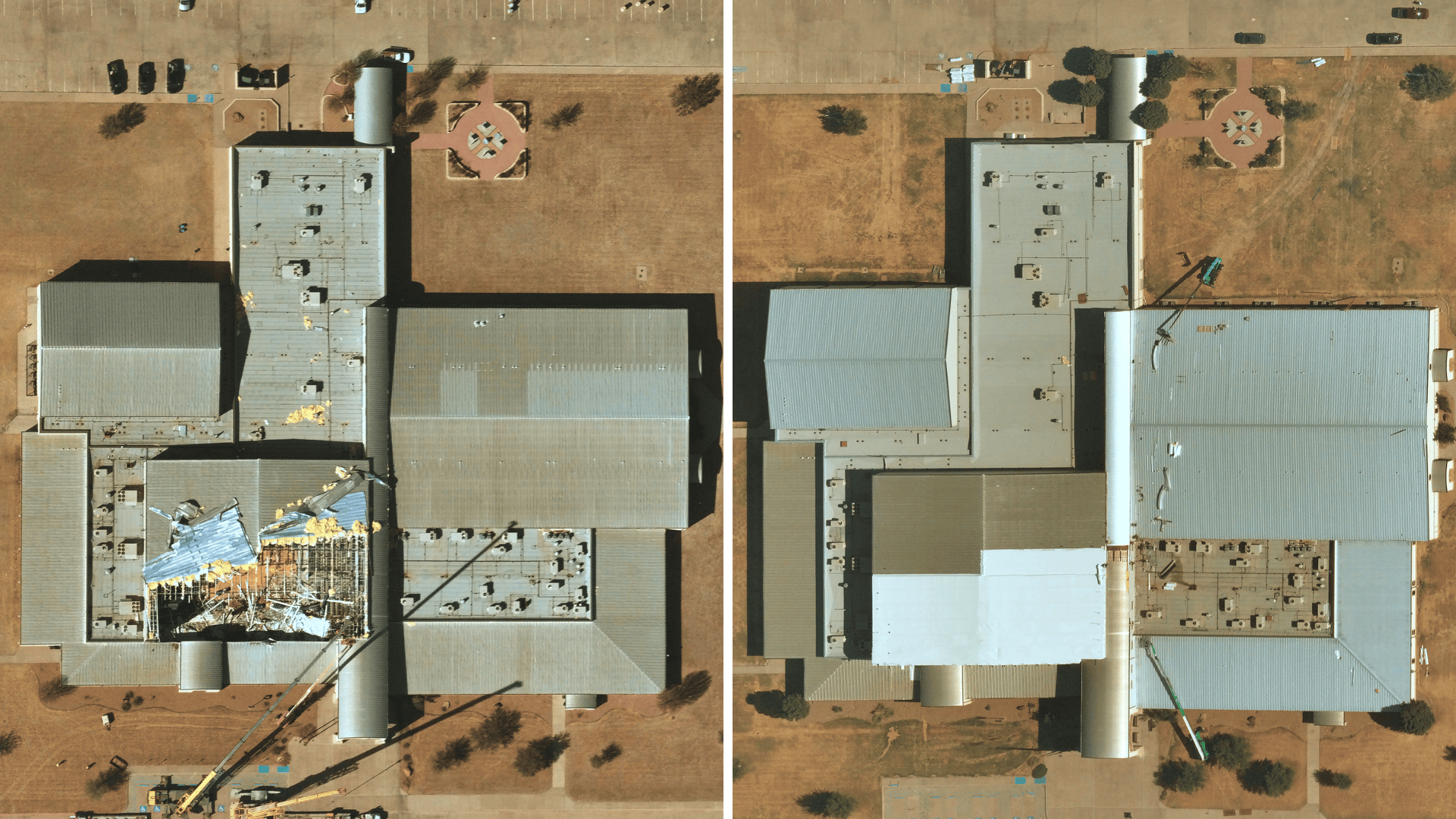
Near Space Labs’ post-catastrophe imagery of a damaged commercial building (left) compared to 90 days later, confirming near-complete repairs (right).
Getting prepared and staying ahead of hurricane season
As hurricane season is here for some and approaching for others, Near Space Labs is prepared to help carriers accelerate claims, reduce losses, and better support customers with highly recent property imagery across all markets and geographies. With us, this season could feel just as smooth as any other time of year!
______
We are actively capturing pre-CAT imagery of high-risk areas in Florida. To gain access or request other locations, fill out your information to speak with our team at nearspacelabs.com.