Remote sensing via stratospheric Swifty robots are empowering more prepared, resilient, and sustainable communities
Climate change and the impact of growing populations on the planet has caused an increase in catastrophes worldwide. And as communities grow and spread to new areas, people are experiencing these events more frequently and more severely. The rise in climate disasters and their impact on neighborhoods has generated an urgent need for high-quality data to mitigate, prepare, respond, and recover from events.
Near Space Labs’ stratospheric technology is built to rapidly respond to unforeseen events and deploy to avoid cloud coverage and weather conditions more easily than other providers. This allows us to collect high-resolution imagery of details surrounding damage and the conditions of properties, infrastructures, and the environment after natural disasters like floods, tornadoes, wildfires, and more.
Our balloons fly twice as high as commercial airplanes, but don’t reach space’s orbit which enables us to be highly flexible in our imagery captures. The stratosphere, or “near space,” has historically been untouched by Earth imaging technologies until Near Space Labs. There are tremendous business and technological advantages in the stratosphere, specifically ones that allow us to provide quality and timely geospatial data for disaster management use cases.
This blog will walk you through five different use cases whereNear Space Labs’ high-resolution imagery enhances pre- and post-catastrophe efforts.
- Emergency Preparedness
According to the 2022 Ecological Threat Register, “the global number of natural disasters has increased tenfold since 1960.” The rise in catastrophes has cost billions of dollars in damages, which makes focusing on emergency planning and risk mitigation very attractive to businesses, governments, and emergency management organizations.
Our Swifty robots fly 60,000-85,000 feet in the air and capture 10 cm high-resolution imagery of wide-scale areas. We cover up to 1,000 sq km (or approximately the size of all of NYC’s five boroughs) in a single flight, to help disaster management agencies and others gain comprehensive, high-quality insights about cities, suburbs, and rural areas.
The scale of our imagery, for example, can help AI and machine learning models analyze which properties and areas fall into high-risk zones, provide accurate risk assessments, and build detailed maps to identify hazards and protect critical assets. Frequent and updated imagery of areas, particularly high-risk ones, is also important when preparing for emergencies. For instance, businesses that use geospatial data are able to identify which areas are more prone to damage and can plan accordingly when disasters approach (ie. moving supplies, boarding up windows, securing equipment, etc.). Frequently monitoring areas pre-disaster also generates baseline data to help organizations compare ground conditions, measure the extent of damage after an event occurs, and create better risk mitigation plans.
With our highly-refreshed geospatial data, we are helping to protect our valued assets, reduce the level of potential damage, and build resilience in our communities, infrastructures, and environment.
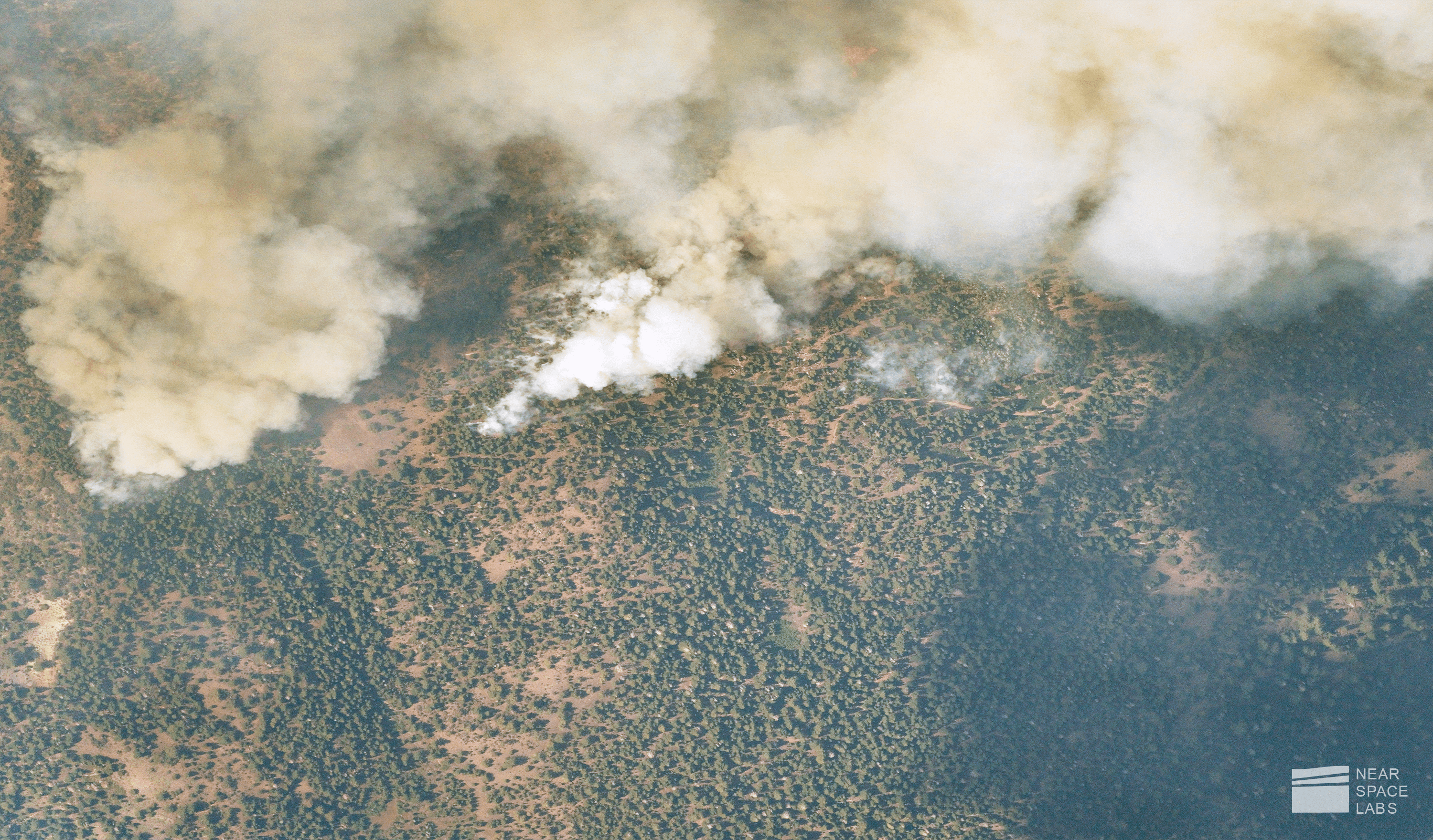
Near Space Labs capture of 2021 Tamarack Wildfires in California. Understanding high-risk fire zones and paths can help emergency planners mitigate and deter future fires. July 20, 2021.
- Emergency Response
Once a disaster strikes, the top priority is ensuring the safety of all people affected. With timely, wide-scale imagery, we are able to monitor an entire affected area to help emergency response organizations identify and prioritize where support is needed and allocate resources quickly and effectively. Our 10 cm resolution imagery shows details of roofing damage, debris in backyard, new cracks in the street, broken fences, damaged landscapes, and more.
Our team is able to mobilize and launch our Swifty balloons directly after an event occurs to capture invaluable and timely information about the conditions of infrastructures, properties, and environments. Other imagery providers like satellites, airplanes, and drones run into issues that hinder rapid imagery captures after catastrophes. For example, airplanes and drones must wait for airspace regulations to clear in order to image a disaster area, satellites are bound to Earth’s orbit which prohibits them from being flexible in the time, date, and location of capture. And more often than not, on-site inspections may be unsafe or inaccessible for days or weeks after an event. With the ability to fly directly after an event without restrictions, we are able to safely collect high-quality, georeferenced data, otherwise lost, to accelerate emergency response and recovery efforts and processes.
Our timely imagery can also be used by state governments as proof for federal assistance in extreme cases. We can collect and process our data in up to 24 hours to provide agencies with high-quality information about the status on the ground in order for them to quickly assess how to handle the situation. Federal agencies can then use our imagery in conjunction with their Joint Preliminary Damage Assessments to confirm if Federal assistance is necessary.
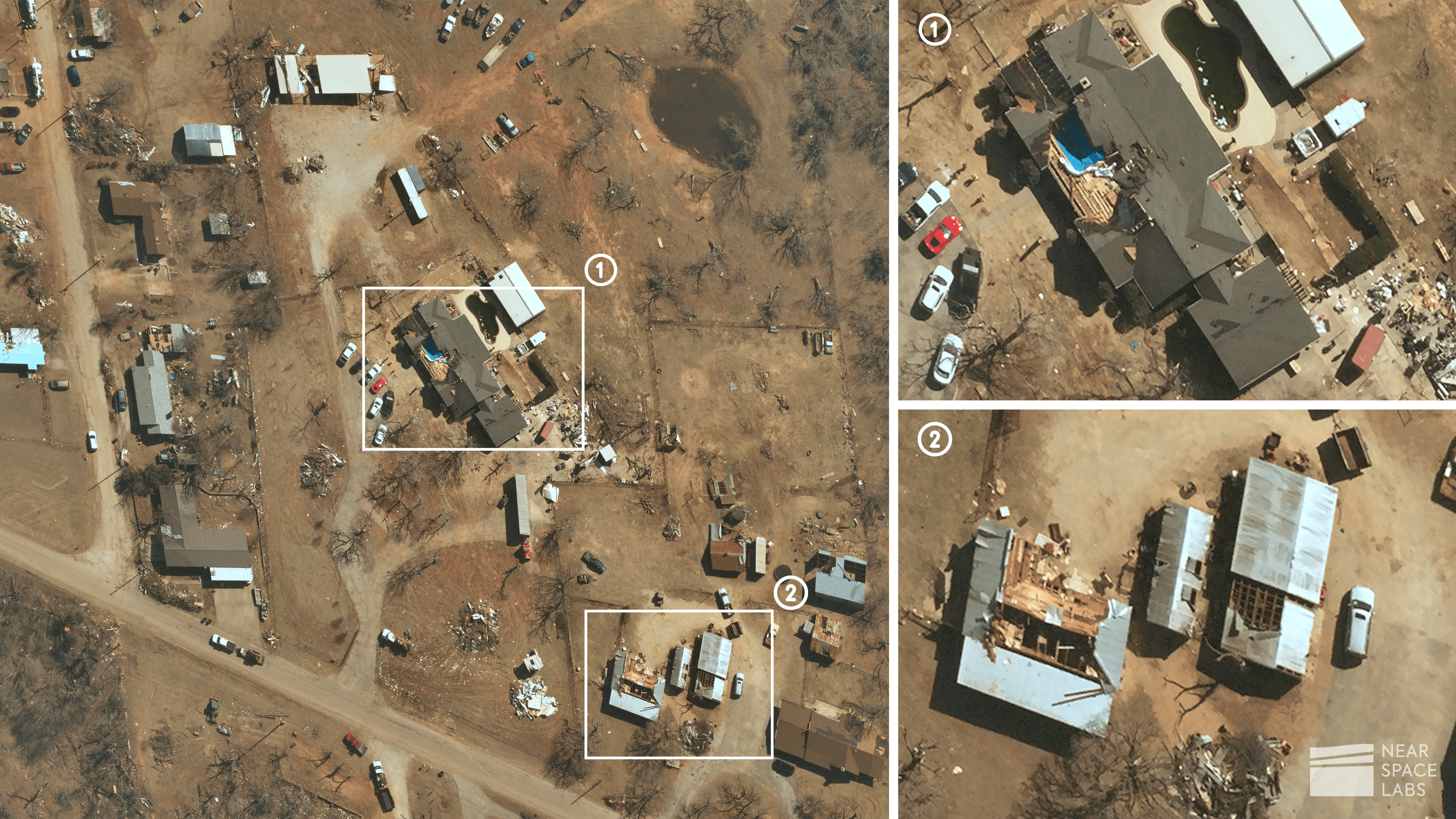
Near Space Labs capture of roofing damage, debris, and fallen trees after an E-3 tornado struck Jacksboro, Texas in March. April 4, 2022.
- Clean up and Recovery
Oftentimes, while emergency response efforts are still underway, the clean up and recovery process also begins. Continued monitoring of an area post-catastrophe helps track recovery progress and identify any additional lasting problems the event may have caused.
Depending on the severity of the catastrophe, the recovery process can take weeks to more than a year to fully transform an area back to health. The process can include tedious and long-term projects such as cleaning up fallen trees and debris in the streets, rebuilding demolished structures and properties, fixing damaged roofs and roads, and more. Our baseline imagery captures are refreshed every 90 days, giving government organizations, insurance agencies, and emergency planners highly updated data to ensure communities are rebuilding quickly and efficiently.
High-quality imagery – both spatially accurate and correctly georeferenced – from the clean up and recovery stage of the disaster management cycle, can also help inform emergency preparation and response strategies. Frequent imagery after a catastrophe can illustrate the length of time it takes communities to revitalize, what damages could have been avoided, and how people can better prepare for the next disaster.
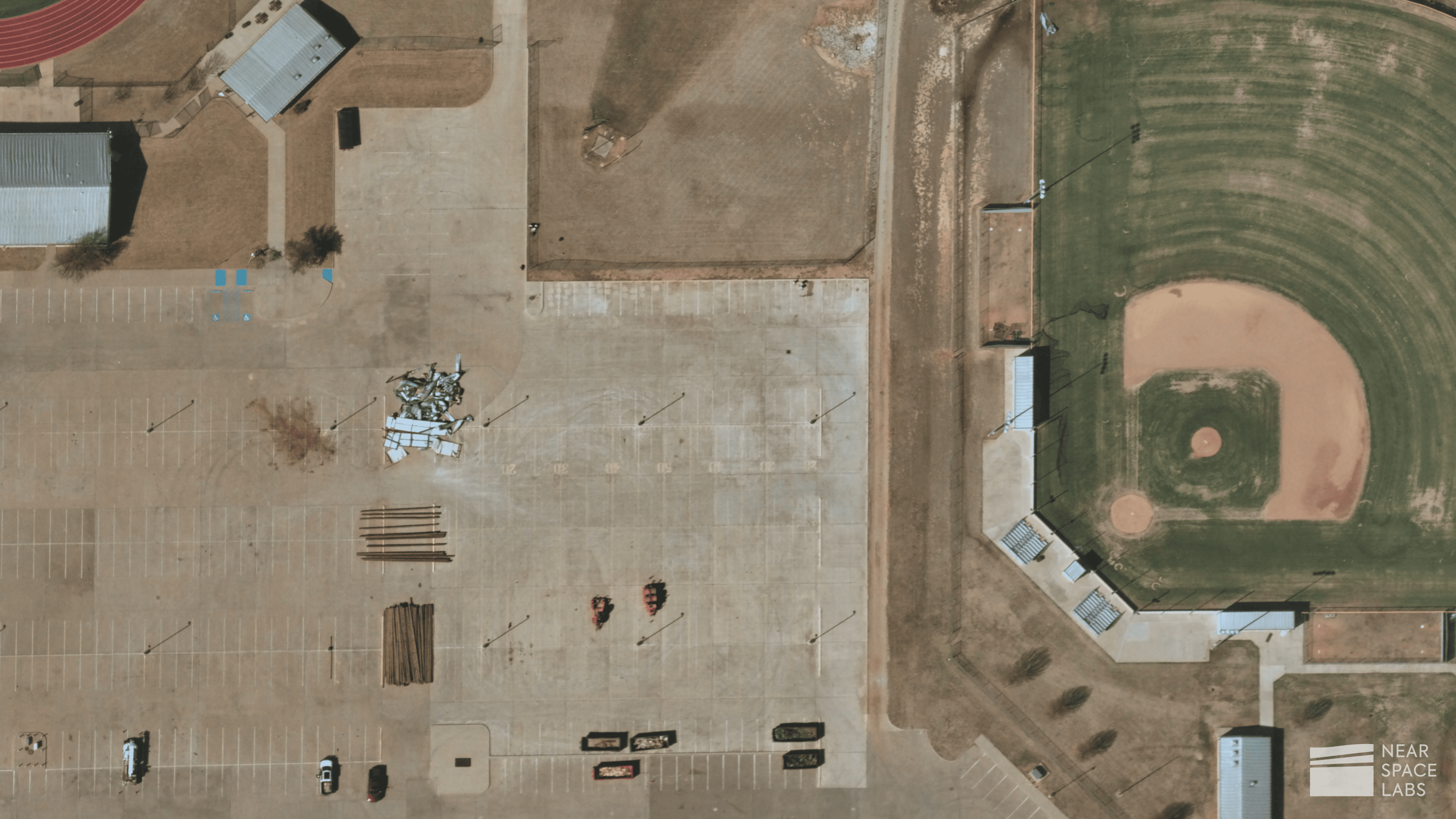
Near Space Labs capture of debris cleanup after a E-3 tornado in Jacksboro, Texas. March 30, 2022.
- Insurance
Our high-resolution imagery helps insurance organizations enhance claims and underwriting processes. Insurers are able to speed up the policyholder’s recovery time, validate claims and combat fraud, determine correct payout amounts, enhance underwriting efficiency, and mitigate risk with wide-scale GIS data.
Claims
With a quick turnaround time from imagery capture to delivery of data, insurance organizations are able to validate claims, assess the extent of damage, and provide quick relief to customers in their time of need with our pre- and post-catastrophe data. Remote sensing also decreases the need for timely, and, sometimes dangerous, on-site inspections to help insurers triage which claims may need a more comprehensive inspection.
Visualize damages before and after disasters such as tornadoes, floods, and wildfires and use our imagery as incontestable documentation of the truth on the ground before and after events.
Underwriting
Our imagery helps insurance organizations mitigate risk by providing a detailed birds-eye-view of their properties or critical assets. Underwriters are easily able to identify hazards, such as vegetation encroachment, and understand which properties lie in high-risk areas, such as Seismic Zones (earthquakes) and Fire Hazard Severity Zones. Our data provides better insights for damage assessments to help underwriters and machine learning models determine more accurate and proper underwriting policies to better benefit the business and policyholders.
Also, by integrating our historic geospatial data into AI and machine learning models, insurance organizations can predict the extent of damages, cost, and payout amounts before the next catastrophe occurs to better prepare and further streamline the underwriting process.
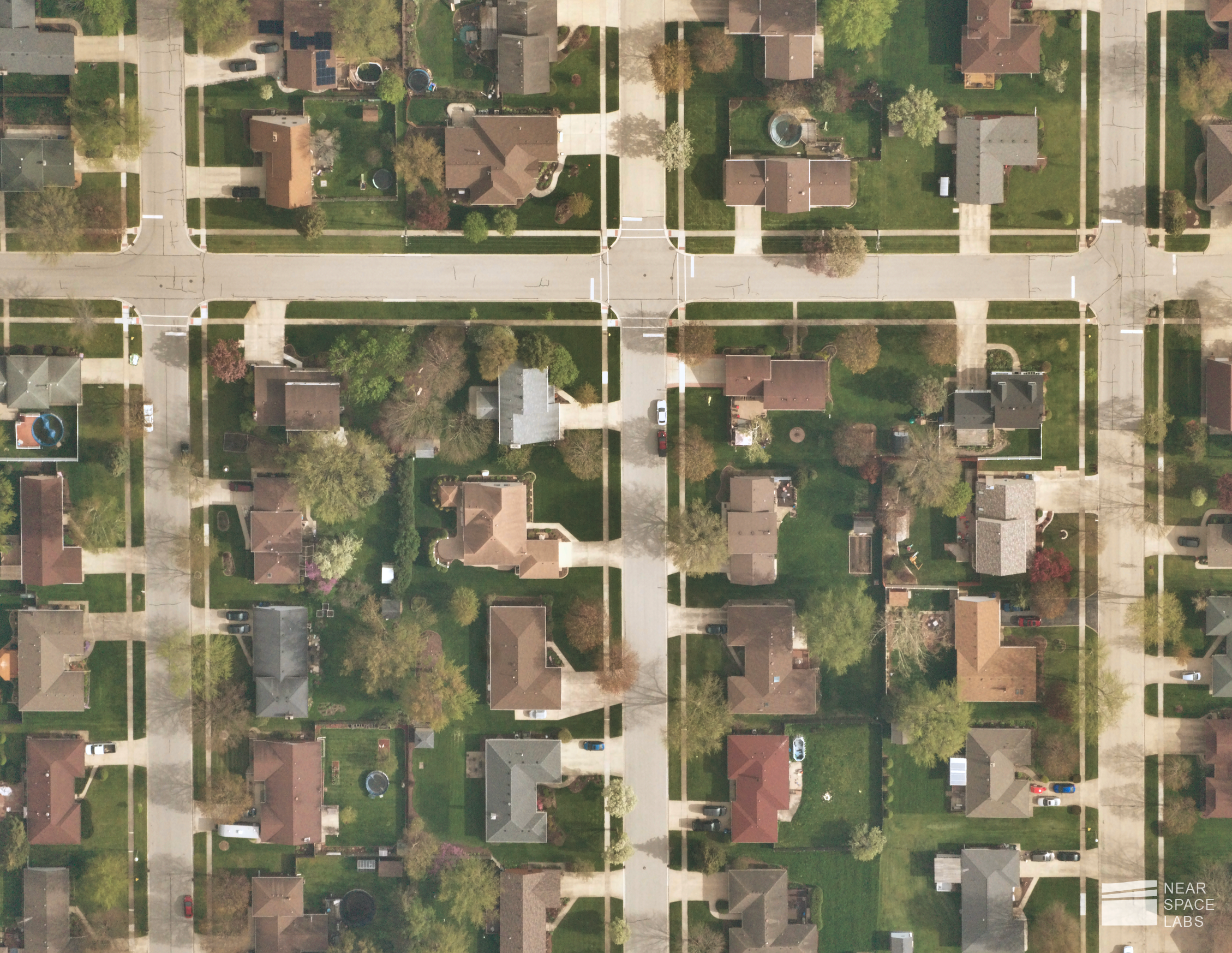
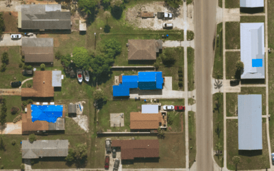
Near Space Labs image of neighborhood in Chicago, Illinois. Visualize hazards such as tree overhang, damaged roofs and cracks in the pavement, and identify assets more prone to damage such as trampolines, sheds, and solar panels to better inform policy, mitigate risk, and enhance underwriting. May 8, 2022.
- Tracking change
From micro-changes such as new potholes in roads or damaged power lines after a storm, to long-term changes such as deteriorating structural foundations or a decline in forest growth, our frequent and historical imagery helps track these situations to support restoration plans, monitor redevelopment, and analyze how the environment is affected over time.
Since rebuilding communities after a devastating event can take years, that means thousands if not millions of changes are taking place to ensure a stronger and more resilient environment.
With high-resolution imagery from the stratosphere, we are able to capture large swaths of land to help identify and track these changes at scale. For example, we can monitor construction and redevelopment progress to show how an area is evolving after a catastrophic event.
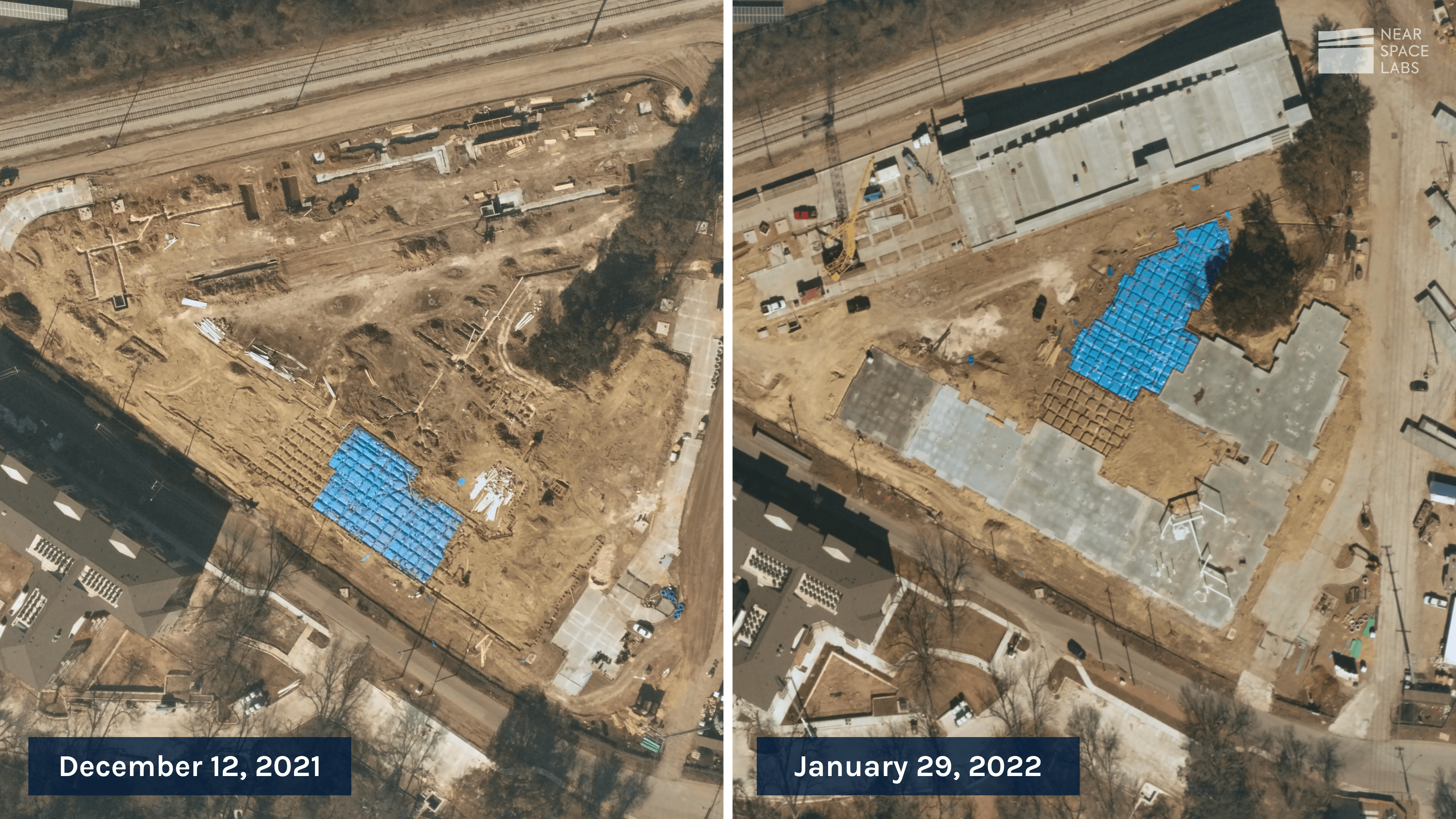
Near Space Labs frequent captures of development progress in Austin, Texas.
High-Quality Geospatial Data for Climate Disasters
These micro-changes are easily identified with high-resolution geospatial data, but it takes repeatable, high-frequency and high-quality data to understand the current and potential long-term effects of climate disasters. By repeatedly imaging areas of the forest for example, we can understand how catastrophes are affecting tree population growth, wildlife, and the health of natural environments. We can use highly refreshed imagery to understand how urbanization and population growth is causing a rise in natural catastrophes, and identify ways to combat this such as optimizing the layout of cities and neighborhoods and minimizing developments in high-risk areas.
If we do nothing about the small changes occurring in our world, they will eventually add up to leave massive effects on our livelihoods and the planet we live in. Our technology is built to monitor these micro-changes at scale to inform and address climate change challenges before they get even more out of hand. By tracking these changes frequently, we can help put better action plans in place, educate people, businesses and organizations on ways to mitigate risk, and create a more sustainable planet.
For more information on how Near Space Labs can enhance disaster management processes, please contact us below.