The view of 2022 from Near Space was one dominated by the ongoing challenges connected to climate change and natural disasters and the ways in which communities of all sizes attempt to mitigate impacts and adapt to future change. By democratizing access to high-quality imagery, we believe we can help build a greater future and empower stronger, more equitable and resilient communities. Below, we go through a few challenges related to climate change that we’ve seen impact cities, suburbs, and rural and remote communities all the same, and present how timely, frequently updated, high-resolution earth imagery is, and should be, part of the solution.
The Increase of Natural Disasters and the Impact on Communities
One of the realities about today’s world is that the majority of us have experienced the impacts of at least one natural disaster or extreme weather event either directly or indirectly through family or friends. In 2021 alone, roughly one in ten homes in the US were impacted by natural disasters, nearing $57 billion in property damage, according to CoreLogic, a property research organization. As the severity and frequency of these events continue to grow, so does the need for faster, more responsive solutions to help communities of all types recover and rebuild in a timely manner.
To illustrate this point, let’s evaluate the experience of two towns following separate natural disasters that occurred in 2022. In March, a tornado swept through the small town of Jacksboro, TX, located roughly one and a half hours northwest of the Dallas-Fort Worth metro area, leaving a trail of destruction. Six months later, the similarly small town of Arcadia, FL was hit by Hurricane Ian as it made a last-minute turn and cut across the state of Florida, just to the south of Tampa. Due to their small populations (under 10,000 people) and relatively rural locations, both Jacksboro and Arcadia are regions that lack sufficient imagery coverage. As both towns began to pick up the pieces to rebuild, it quickly became apparent that this lack of data would severely delay recovery efforts for individuals and businesses alike.
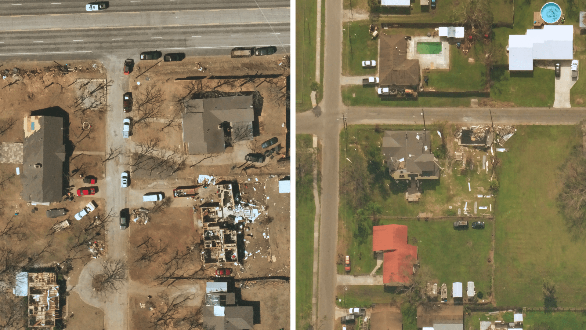
10 cm imagery captured by NSL of tornado damage in Jacksboro, Texas (L) and Hurricane Ian damage in Arcadia, Florida (R).
In order to process claims and distribute payouts quickly following natural disasters, the insurance industry relies on data to validate and assess damage. For residents of Jacksboro, the issues stemmed from a lack of baseline data, or what the insurance industry calls, “blue sky imagery.” Basically, insurers need to have a clear picture of what a property looked like pre-catastrophe, in order to evaluate what exactly was damaged post-catastrophe. Similarly, the quicker that insurers can gather data about what was damaged post-catastrophe, the faster they can process claims. In the case of Arcadia, many imagery providers had been so focused on the metropolis region of Tampa leading up to the landfall of Hurricane Ian, that they were not prepared to provide post-catastrophe data coverage to rural areas such as Arcadia.
As an individual living in Jacksboro or Arcadia, the lack of baseline data coverage following the March and September events meant that you would likely have to provide additional photographs, receipts or information to substantiate your claim to your insurance provider that your shed or house, for example, had been damaged. On the insurer’s end, the claims process was far more complicated, requiring extensive time on the ground and evaluation to validate claims and distribute insurance payouts to begin the all-important task of rebuilding.
Although the examples of Jacksboro and Arcadia are both specific to rural, less populated areas, similar problems of insufficient and/or delayed imagery data can plague recovery in large cities and metropolis regions all the same. And now more than ever, due to a continual rise in catastrophes, it is essential that high-quality data is captured quickly and frequently in all regions to not only help communities rebuild, but also to help organizations, emergency response teams, and insurers prepare and mitigate future loss. At Near Space Labs, we capture post-catastrophe data with the flexibility and speed that is impossible to achieve with other imagery providers, as well as offer continuous monitoring of impacted areas to evaluate recovery progress, help identify trends, and recognize areas that may need further assistance.
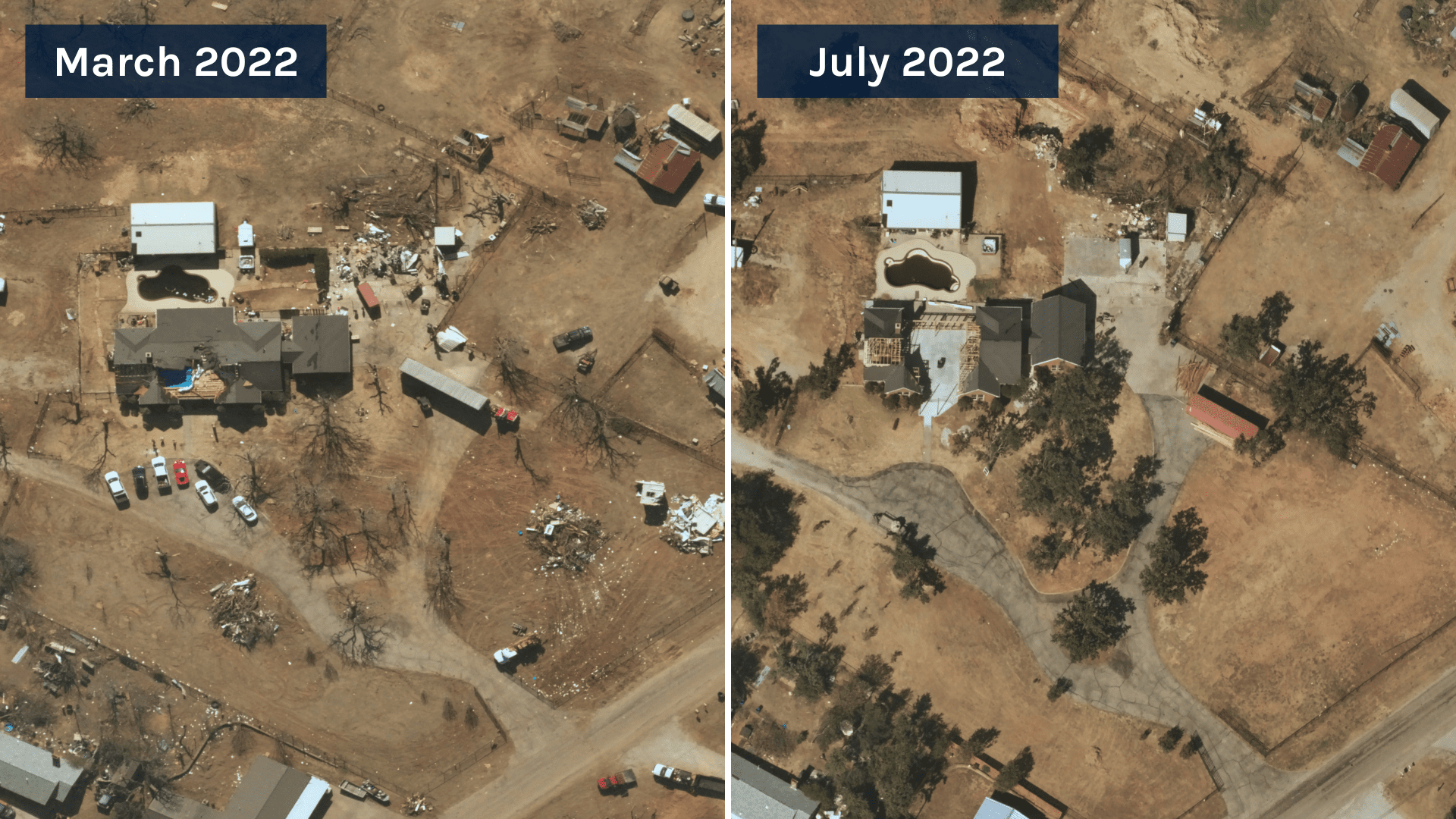
Our ongoing capture capabilities allow for frequent monitoring of recovery following extreme weather and natural disaster events. 10 cm capture by NSL of Jacksboro, Texas.
The Growing Need for Climate Action from Governments (both big and small)
Government action to address climate change over the past thirty years has been inconsistent, at best, but the general trend has continued to grow in recent years as the impacts have grown more stark. The Inflation Reduction Act (IRA), passed in August, provided a near-term road map for how the U.S. government hopes to drive change to mitigate the impacts of climate change on communities and adapt infrastructure to better meet the needs of the changing world.
At Near Space Labs, we view our work as providing the data backbone for the mitigation and adaptation components of climate change. Both mitigation and adaptation require high-quality, high-frequency imagery that empower scientists and governments to make better informed decisions regarding the communities that they serve. As referenced previously, we cannot afford to only evaluate large metropolis regions for climate change impacts. We must include smaller, rural areas that often have fewer resources at their disposal, yet feel the impacts of climate change just as harshly as their neighboring cities.
Beyond providing data coverage for all types of communities, we must also work to better track the ongoing impacts of pollution from cities and manufacturing and extraction industries. While commitments to reducing emissions have exploded in recent years from state and local governments, as well as corporate entities, validating the efforts has lagged far behind. Near Space Labs’ imagery will play a major role in the ongoing monitoring of these types of pollution so that communities can be more informed about the threats to their physical health, as well as the impacts on the fight against climate change.
Looking Forward to 2023
We’ve learned a lot in 2022 about the challenges communities, businesses, and organizations face in regards to mitigating and adapting to climate change. To apply our learnings into the 2023 year, Near Space Labs is accelerating operations to provide 100% coverage of the continental United States to ensure all communities receive equitable attention and support as we fight climate change.
We will be covering communities, both small and large, to help insurers, municipalities, emergency response teams, and individuals expedite the recovery process following natural disasters. We also look forward to playing a more active role in the monitoring and validating of emission commitments from governments and industries so that communities have the information necessary to better look after their health and environmental priorities.
Near Space Labs is impassioned by the opportunities to create positive change within the work that we do on a daily basis, and through widely accessible, high-quality earth imagery, we believe we can be a part of the solution.