Company Seeks to Empower Individuals and Organizations to Create Meaningful Change Through High-Resolution and High-Recency Earth Imagery
BROOKLYN, NY – September 7, 2022 – Near Space Labs, the cutting-edge geospatial data and Earth imagery company, today announced the launch of its Community Resilience & Innovation Earth Imagery Grant program that will make its 10 cm ultra-high resolution imagery available for free to nonprofits, researchers, and universities, among others.
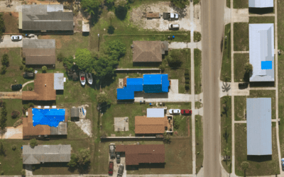
Given the constantly changing urban landscape, Near Space Labs (NSL) will provide imagery of the most populous US cities for a 12-month period to participants of the program. The aim is to provide highly updated, high-quality imagery data to those who may otherwise be unable to access it due to budgetary or accessibility restrictions. Grant participants will be able to implement the imagery data into key studies to build innovative models, research new hypotheses, and identify innovative solutions in urban areas. The images will be available through NSL’s recently launched XYZ Tile API and participants will have the option to renew their participation after 12 months on a case-by-case basis.
“On this exact day five years ago, we launched Near Space Labs with a mission to make high-quality Earth imagery universally accessible to empower better decisions and inspire novel solutions,” said Rema Matevosyan, co-founder and CEO of Near Space Labs. “We want to provide the most recent and high-quality data on the market to not only to our enterprise customers, but to those doing equally important work for the betterment of our overall society. It is our hope that our ability to extend access of our imagery database to a broader set of researchers and those who have limited budget will allow them to gain a more comprehensive understanding of their analyses as they work to identify key issues and develop solutions to the challenges we face everyday within our cities, suburbs, and rural areas.”
Ideal candidates for the program are those who work in academia, urban researchers, students studying geospatial data, Earth data analysts, and nonprofits, to name a few. To qualify, applicants must be U.S.-based and require imagery from areas covered by NSL’s current flight paths in the lower 48 U.S. states. Grant applicants should be in need of imagery datasets that consist of the following characteristics: high volume, ultra high-resolution, and high recency (annual to 90 day refresh). Ideal projects will seek to develop a cohesive understanding of urban change and how it may impact society as a whole and the specific needs of local communities.
The selection process involves a detailed questionnaire and application, as well as project and organization vetting. To view and complete the application, please visit nearspacelab.com.
University student Maria Alba participated in the Community Resilience & Innovation Earth Imagery Grant pilot program, using imagery data from NSL to build a road detection model for her undergraduate thesis.
“Access to Near Space Labs’ data opened the door for me to build a model that could reliably detect various types of road surfaces, and be used to enhance potential mobility, infrastructure, and city planning use cases, ” said Maria Alba. A blog post about Maria’s project can be read here.
The public roll-out of the program follows the company’s launch of its advanced fleet of Swifty 3 stratospheric imaging robots. Using high-altitude weather balloons and proprietary sensors and software, the Swifty 3 robots reach elevations twice that of commercial flights, capturing incredibly high-resolution, high-frequency images of landscapes, man-made structures, and changes occurring on the planet. The company works with planners and decision makers across many industries and use cases, including:
- Insurance claims assessments and risk evaluations
- Natural disaster response and recovery
- Monitoring of infrastructure including roads, bridges and critical facilities
- Environment, conservation, and pollution monitoring
The industry-leading Swifty 3 robot was recognized with an honorable mention by Fast Company’s 2022 World Changing Ideas Awards in the AI & Data and Best World Changing Idea in North America categories.
# # #
About Near Space Labs
Near Space Labs is a cutting-edge geospatial data company on a mission to democratize access to highly-updated, high-resolution Earth imagery. Co-founded by CEO Rema Matevosyan, CTO Dr. Ignasi Lluch, and Chief Engineer Dr. Albert Caubet, Near Space Labs provides timely, wide-scale, commercially available imagery with the largest zero-emission balloon fleet in the stratosphere. Near Space Labs is revolutionizing the way that businesses, communities, municipalities, and researchers gather data to help solve some of the world’s biggest challenges such as urbanization and climate change. For more information, visit nearspacelabs.com
Near Space Labs Contact
pr@nearspacelabs.com
Media and PR Contact
Truc Nguyen
truc@mulberryandastor.com