How high-quality geospatial data and Earth imagery is enhancing digital and smart cities
As governments, technology consultants, and sustainability firms are digitizing cities around the world, they require high-quality data to map out areas, define algorithms, and run analyses to provide meaningful insights. If you aren’t familiar with digital and smart cities, first read our blog The Importance of Assessing and Aligning Relevant Data to Enable Digital Cities.
High-quality Earth imagery is one of the many types of data that is critical to the success of smart cities. Near Space Labs uses zero-emission stratospheric robots, called Swiftys, to image areas of interest using 10 cm optical imagery. We are empowering the creation of smart cities by providing highly updated, high-resolution, and customizable geospatial data at scale without compromises.
Digital City Challenges and Near Space Labs’ Solution
To date, organizations, businesses, and governments building digital cities have a number of challenges around accessing reliable high-quality geospatial data for their areas of interest. Although a majority of the geospatial data captured is of the top most populous cities in the world, organizations still have limitations around the recency of data they can access, the level of resolution they’ll receive, and how much they’ll be able to customize the capture to meet their requirements for those areas. For sites outside of populated areas, the chances of getting that data gets even more slim. And, above all this, there are budgetary considerations, so compromises are often made to use lower quality data and/or providers. Below, we’ll explore each barrier in more detail and explain how Near Space Labs is addressing these issues and strengthening smart cities through accessible, high-quality data.
Location
- Challenge – The top 10 cities in the world currently have the greatest access to geospatial data for building digital cities. New York and Singapore are recognized as the first smart cities in the world and more are expected to come online. But what does it take for cities in different areas to follow suit?
Major cities are covered by imagery providers more frequently than less populated areas, however they may still receive low-quality, low resolution data not fit for building information modeling (BIM). Thus, the challenge lies with the quality of current coverage of the top 10 cities and the lack of coverage in areas outside of these top cities, such as suburbs, rural areas, farmlands, and remote locations. A majority of the world’s population resides outside of the top 10 cities, yet have the lowest coverage, forcing governments, city planners, and consultants to rely on outdated data to make critical decisions about their livelihood.
- NSL Solution – Our nimble technology allows our team to launch from nearly anywhere at any time of the day, enabling us to easily fly over entire cities and underrepresented areas to capture the highest quality data available on the market. We capture up to 1000 sq km, or the area of all of New York City’s five boroughs, in a single flight – providing government policymakers and administrators with wide-scale coverage to build intelligent smart cities. With our solution, underrepresented cities and other areas can gain high-quality insights to help drive decision making around development planning, infrastructure health, repairs, sustainability, and more.
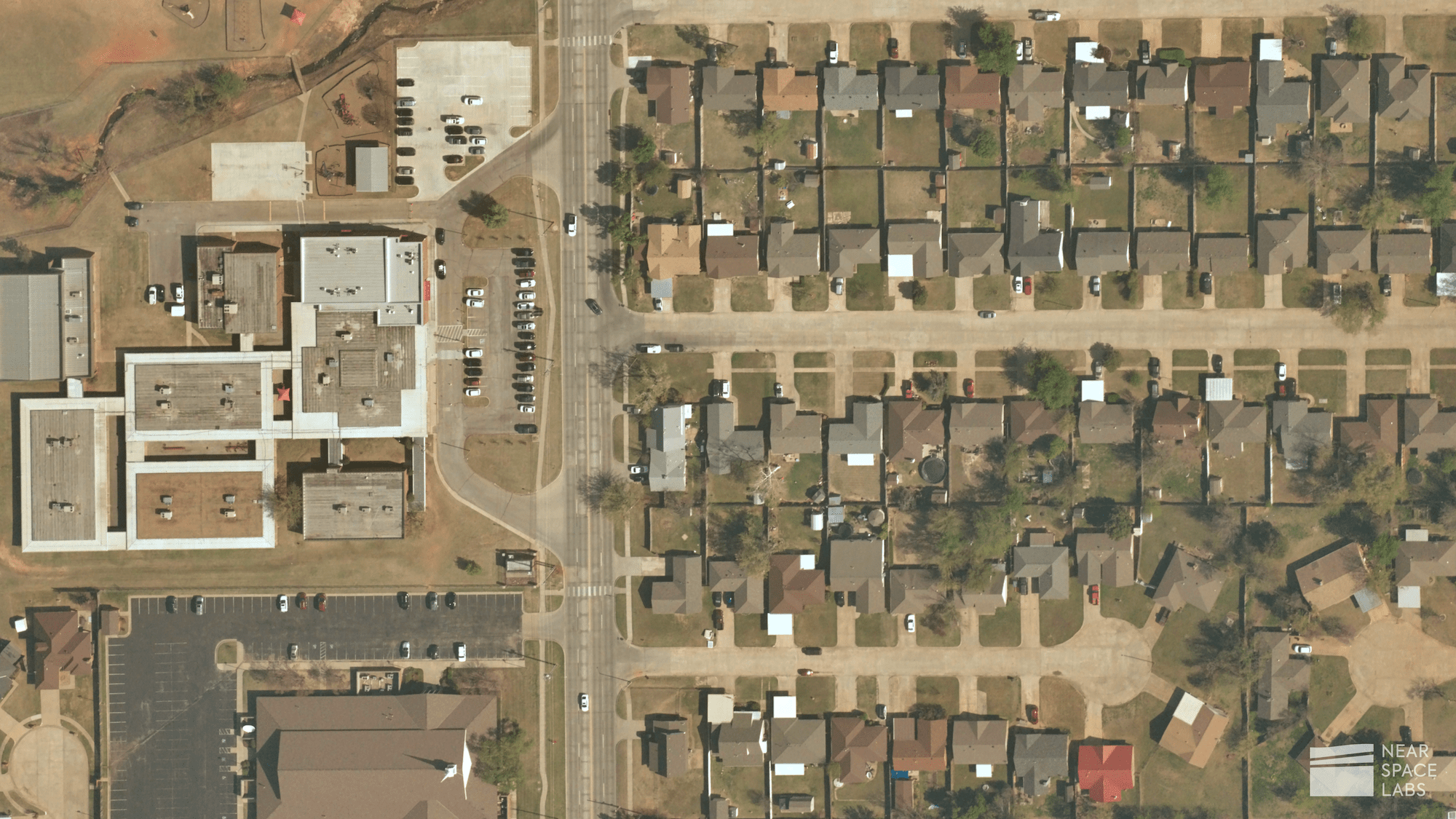
10 cm imagery captured of the suburbs of Oklahoma City.
Frequency and Recency of Capture
- Challenge – Most geospatial data and imagery providers can’t capture areas fast enough to understand how quickly the world is changing. For example, a pothole on a busy street can arise within a day, which means yearly, quarterly, or even monthly refresh rates are not enough to capture the micro-changes occurring in our cities.
- NSL Solution – Near Space Labs’ balloon technology flies 5x (or more) per day to capture minuscule changes before they lead to potential disasters. Co-registering our high-frequency data with local data can uncover the bigger picture. For example, pairing our imagery with LiDAR and infrared data enables users to develop highly accurate 3D models. Our data also equips construction companies with detailed records of development progress and updates which are usually required by their clients. We are able to customize our frequency to our customers’ needed cadence giving them the flexibility they need to show progression and make critical decisions.
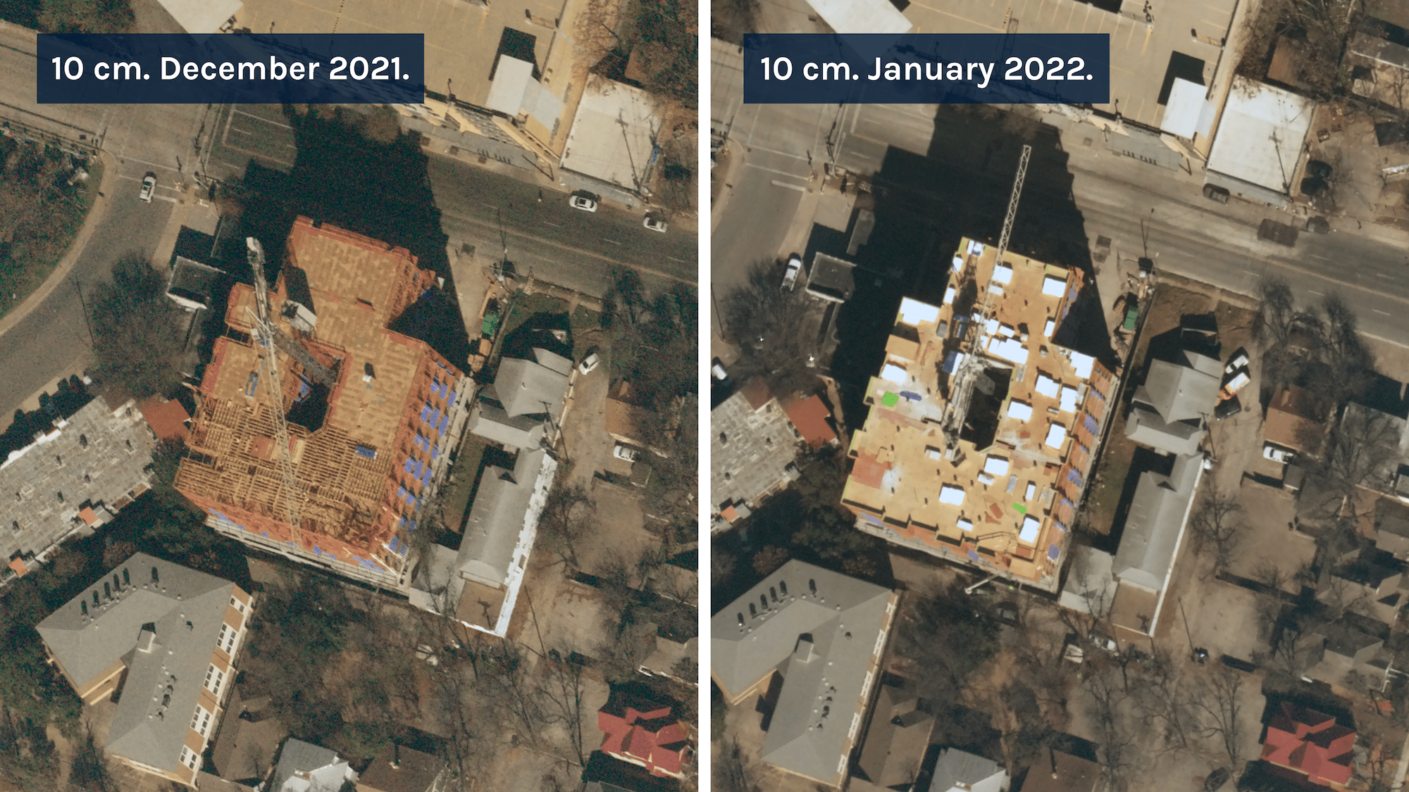
10 cm. Construction progress from December 2021 to January 2022.
Resolution
- Challenge – In order to make well-informed decisions about virtual or real-life cities, we need to understand in detail the conditions and state of our cities’ frameworks, infrastructures, utilities, roads, lands, and environments. Current resolution from satellites and airplanes is too low for organizations or machine learning models to draw confident conclusions for the problems they need to solve like city planning, repairing a public utility, and installing broadband wireless services.
- NSL Solution – Our high-resolution 10 cm RGB sensor allows you to see finite details such as cracks in the road, roofing damage, and vegetation encroachment, at a city-wide scale. This level of detail at scale equips organizations with the highest quality data on the market to run analysis and generate the most accurate and reliable solutions possible.
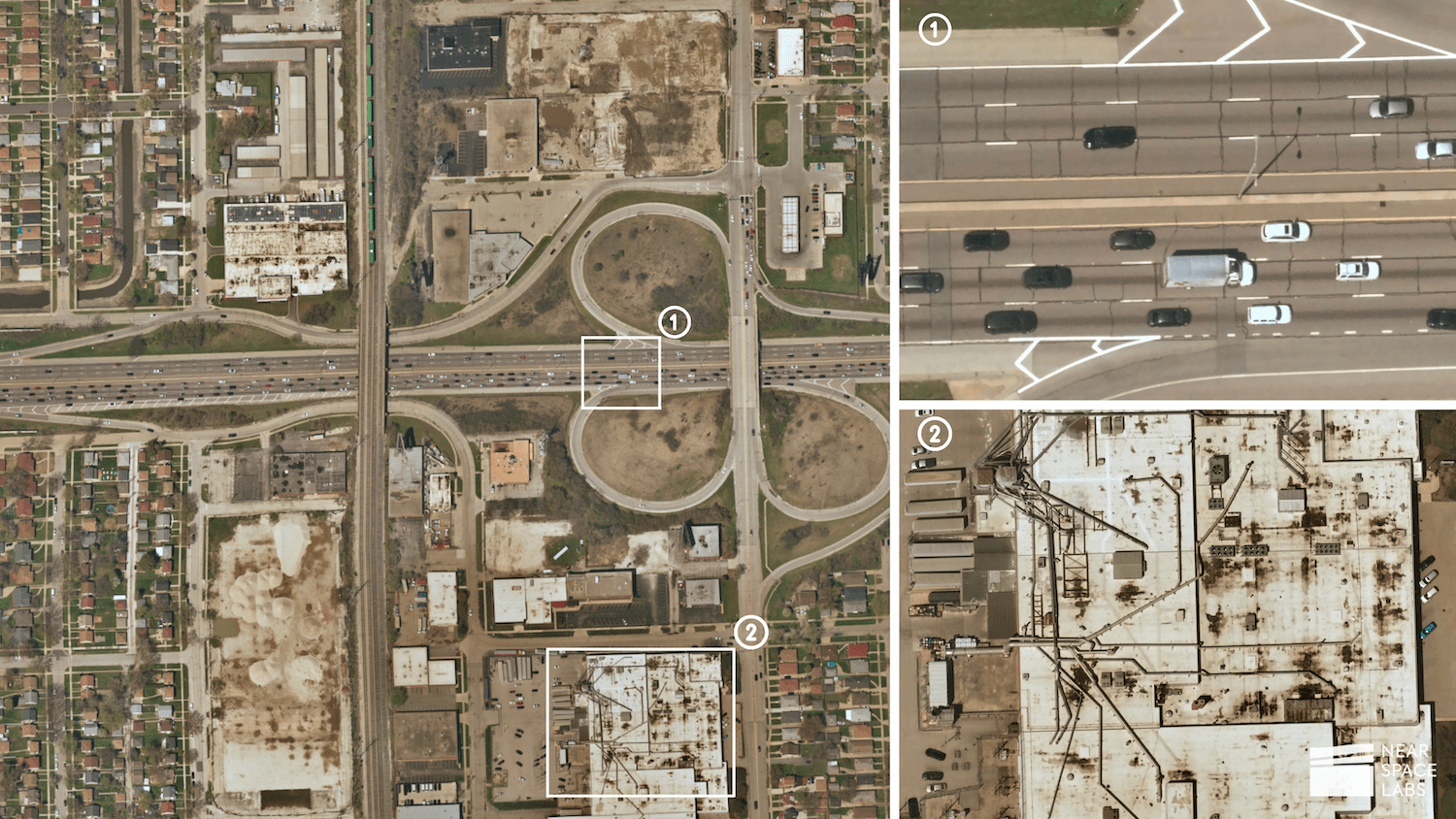
10 cm. High-resolution image of mixed-use development area at scale. Identify road cracks and damages and track the conditions of commercial buildings’ roofs, pipes, and HVAC systems.
Customization
- Challenge – Every city is different. They have different strengths and challenges, and they require custom solutions. The current providers selling Earth imagery to build digital cities include satellites, airplanes, drones, and stratospheric balloons (NSL). Satellites are bound to orbit, making it impossible to customize the date and time of capture; airplanes require pilots and need to adhere to commercial airspace regulations limiting their flexibility of captures; and drones can only cover very small areas, proving non-scaleable and costly.
- NSL Solution – We operate in the stratosphere, using zero-emission, light-weight, and nimble technology. The nimbleness of our device allows us to be highly flexible and adapt to different use cases and specifications quite easily. For example, you can customize your imagery captures by:
- frequency – as often as sub-daily collections
- time and date of capture – we easily work around cloud coverage and capture areas at different sun positions
- angle of capture – up to 30 degrees off-nadir
- delivery format – API, ArcGIS Pro, Geotiff downloads
Our Swiftys are also built for plug-and-play payloads and will easily integrate different sensors such as near infrared (NIR) sensors to track soil and crop health or short-wave infrared sensors (SWIR) to track emissions. We are also able to mobilize and deploy quickly around timely events such as catastrophes and unplanned circumstances.
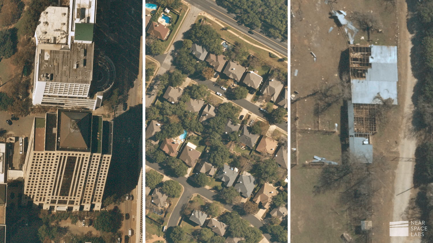
10 cm. Near Space Labs images showcasing customization of capture angle, location, and time, and date of capture after a natural disaster. (left to right)
Scalable Solutions
- Challenge – When you’re building a digital or smart city, all of the points we raised above are essential to deriving meaningful insights from your model. Thus, the challenge is to find an imagery provider that allows you to maximize the resolution, frequency, and ability to customize the data you require, at scale.
- NSL Solution – Our proprietary Earth imaging hardware is designed, built, and deployed with our customers in mind. The new generation of our Swiftys allows us to capture large swaths of 10 cm data within a few hours, providing our customers with near real-time data of their areas at scale to accelerate and enable the development of smart cities. With our balloon based approach, we aren’t sending multi-million dollar satellites into space, or using an expensive and emission polluting airplane to capture data. We build and deploy our technology more efficiently and timely than competitors, allowing our customers to gain access to the most updated, accurate, and robust dataset possible in order to develop scalable solutions.

Near Space Labs’ proprietary Swifty robot and balloon technology.
What’s Next?
Geospatial imagery is just one aspect of building a digital city. Leveraging multiple data sources will help create the most accurate and reliable digital cities possible so organizations can draw meaningful insights, strengthen the foundation of our world, and enhance the quality of life for everyone.
If you are interested in speaking with our team about high-quality Earth imagery for digital and smart cities, please contact us below.