Companies are increasing situational awareness, enhancing models, and maximizing ROI with Near Space Labs’ 90-day refreshed imagery
Is your company making decisions with outdated data? Are you exploring imagery-based processes and wondering what recency and frequency is “good enough”? In this blog, we will expand on how highly refreshed data can unlock more opportunities, increase profits, and boost insights for companies when used strategically and consistently.
Recent and frequently updated data allows users to identify change or set baselines. Changes to infrastructures, environments, and communities are occurring constantly, but without historical and consistent imagery, many changes may go unnoticed or unreported. Without accurate data, businesses across industries are left making critical decisions about their assets without truly understanding their current conditions. This can result in wasted time, money, and opportunities to increase profits, customer satisfaction, or overall efficiency.
For example, without access to recent data, an insurer may pay out a claim after a storm damages a property, unaware that one month before the roof was already damaged due to negligence. A land trust surveyor may be unable to identify any unwarranted construction occurring on their easement properties before an entire ecosystem is affected. Or a city planner may approve an inefficient development plan due to recent changes to the landscape and surrounding area.
Take our recent capture of this neighborhood in Illinois for example. When comparing the existing images found on Google Maps (as of today, October 25, 2022) you can see that most of the development is missing. Without means to visit this neighborhood in-person to validate its progress, the development of this community could go unreported to city planners, insurers, and other affected residential monitors. When expanded across neighborhoods around the US or worldwide, this gap in recent data poses serious problems for businesses.
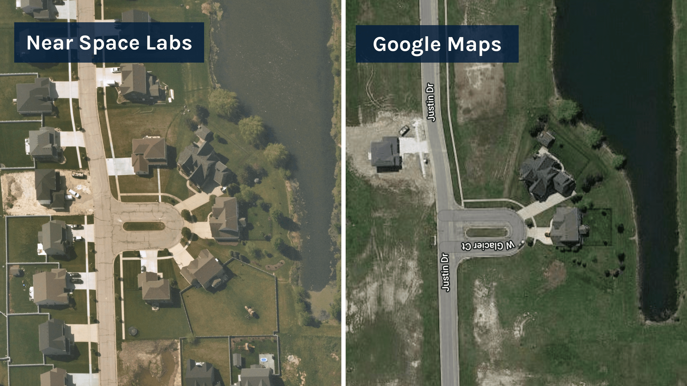
Near Space Labs’ capture (L) of a developed neighborhood in Illinois from May 13, 2022, compared to the image available on Google Maps (R) as of the date this article was published. Google Maps location – 41.403298, -88.253011
On top of the importance of recent data, frequently captured data demonstrates what and how things are changing over time and allows organizations to make the most well-informed decisions. So the next question is, what does “highly refreshed data” even mean? Does that mean yearly? Semi-annually? Quarterly? Every day? Every minute?
When it comes to data frequency, we’ve found that business’ needs fall into three categories 1) they have a set timeline in place (ex. seasonally monitoring areas) 2) they need to access as much data as possible (ex. real or near-real time monitoring) or 3) they need to figure out their data ingestion model.
For this third group, we’ve collected a few learnings. While data updated every day or every minute sounds ideal, it would be extremely costly and take an immense amount of time and resources to digest and use in a feasible way. And with data updated annually, businesses miss out on a whole year of changes. So where does that leave us?
For businesses that need to identify detailed changes at scale, we believe data refreshed every 90-days is the sweet spot. These quarterly updates show seasonal changes during leaves on and off periods, are close enough in time to identify major and minor changes to critical assets and the environment, and allow enough time in between updates for businesses to fully digest, implement, and understand the data they are using.
With current imagery providers, many businesses and organizations are used to receiving semi-annual or annual refresh rates, which leaves them in the dark for the other half of year or 364 days. And if they are receiving higher frequency rates, it’s usually not without compromising on resolution. That is why we built our model to offer 10 cm resolution imagery at a 90-day refresh rate of the most populous cities in the US for insurers, city planners, researchers, and more. We are providing the most reliable and recent imagery on the market to help businesses make better-informed decisions.
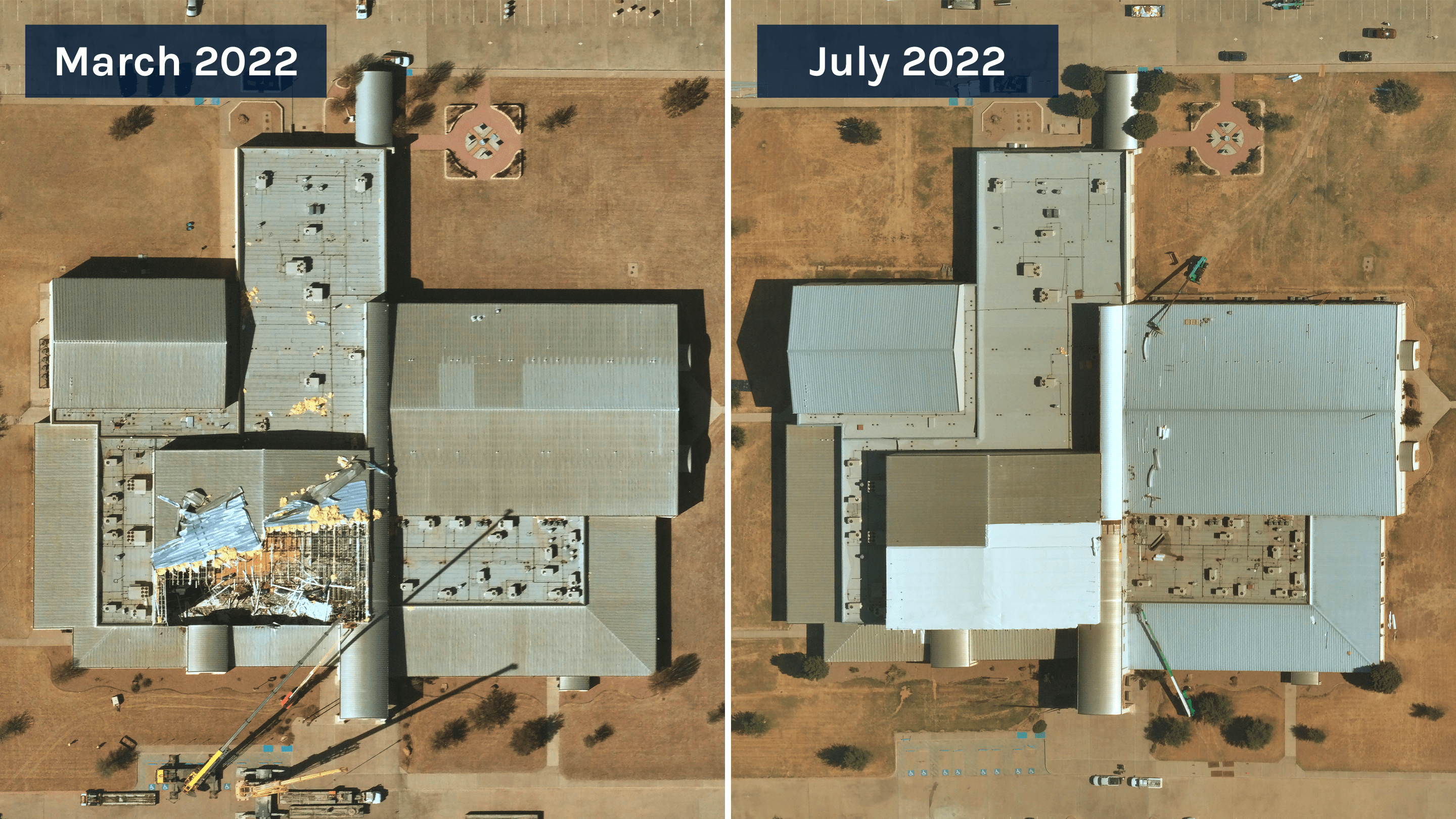
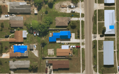
Near Space Labs’ capture of Jacksboro high school 9 days post-tornado showing damaged roof (L). Near Space Labs’ capture of Jacksboro high school 4 months post-tornado showing the roof’s construction and recovery progress (R).
Data teams feed our highly updated data into machine learning models to improve their ability to detect changes and make predictions. Some examples of changes these models can identify include infrastructure developments such as parking lots and traffic lights, new property liabilities including trampolines and cracked driveways, and roofing damages such as water ponding or missing shingles.
The ability to detect these changes at a higher frequency opens countless opportunities for businesses. For example, with imagery updated every quarter insurers can identify opportunities to increase premiums on properties where home improvements weren’t reported, such as an added swimming pool or shed. A machine learning model can detect hazards and potential fire risks such as tree overhang or vegetation encroachment and understand how this changes during the different seasons. And utility owners can identify any damages to transmission towers or lines and have them fixed before it negatively impacts the community and turns into a power blackout.
Frequently updated and recent imagery gives businesses and organizations all the pieces of the puzzle and allows them to make decisions without questions. It serves as baseline data for them to draw comparisons and can enhance the way decision makers, models, and business’ as a whole operate.
Start making decisions with all the facts. Contact us below for more information on how frequently updated and recent imagery can enhance your business.