Learn how high-quality, high-frequency geospatial data can reveal how the world is changing at scale
In order to keep up with how rapidly the world is changing, high-quality data must be captured and delivered at a high-cadence. With micro-changes occurring everyday – like new potholes and cracks in roads, new construction, traffic congestion, and roofing damages – yearly, monthly, or even weekly coverage isn’t regular enough to build highly-accurate change detection models, digital and smart cities, or scalable solutions to address how these variations are affecting our communities. The ability to track these micro-changes at a city-wide scale is how sustainable and thriving urban areas, suburbs, and rural neighborhoods will be developed.
One solution is high-resolution, high-frequency geospatial data. Remote sensing can be used to survey cities at a massive scale, and give city planners, government administrators, and policymakers the ability to build precise models to inform decisions about transportation, infrastructure health, and sustainability. Here’s how:
- High-quality Earth imagery is important because it gives visibility into the minute details of our world. 10 cm resolution allows you to see the conditions of pavements, roads, roofs, buildings, and landscapes, and can be used to develop accurate and confident spatial measurements. Remote sensing imagery empowers machine learning models — using highly accurate, georeferenced data — to create smarter algorithms and thus better insights. For example with higher resolution, machine learning models not only can identify vehicles on the ground, but it can decipher between the type of vehicle (ie. cars, minivans, trucks, motorcycles, etc). Not only can it identify roads, it now can understand the conditions of the roads, visualizing cracks, new obstructions, or sinkholes. This, for instance, would help autonomous vehicles learn how to react safely to unforeseen changes on the roads.

Near Space Labs capture of the 290 Freeway in Illinois that suffers from deterioration and pavement cracking. May 7, 2022.
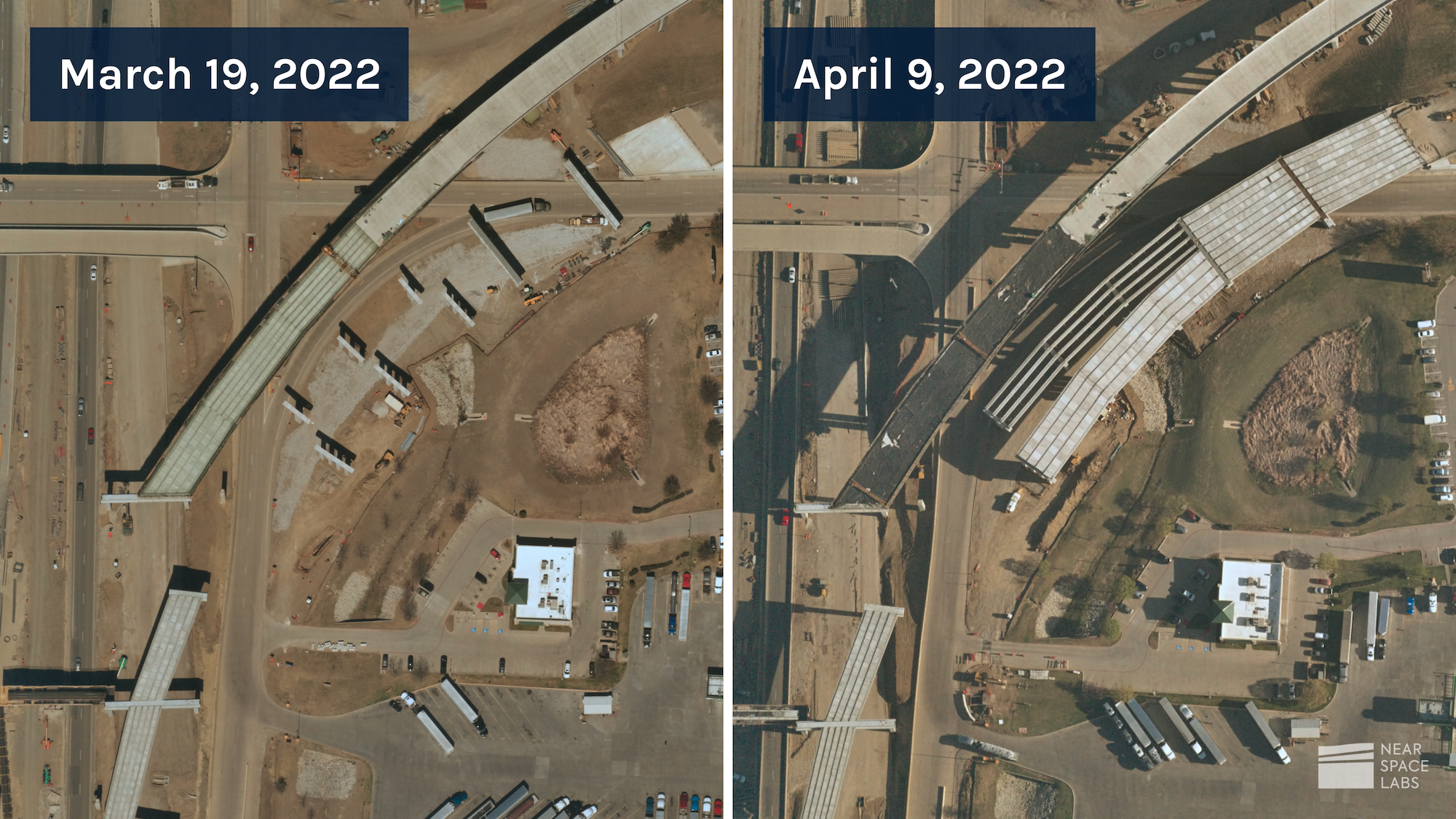
- High frequency data, at scale, is the key to understanding when and where changes are occurring, and can help identify solutions and preventative measures to mitigate risks in our cities, suburbs, and rural areas. For example, many construction companies are required by their clients to provide weekly or even daily updates of construction progress. Remote sensing via stratospheric balloons allow for sub-daily capture rates that can be used to track progress, build digital twins to forecast development, and create 3D models of buildings, roads, and other infrastructures to understand layers of their physical structure and efficiency levels.

Near Space Labs capture of a highway bridge’s construction progress.
- Customizable imagery captures allows city planners, government organizations, and more to see the world from different perspectives in order to build an accurate depiction of our foundations, infrastructures, and environments. A few ways to modify imagery captures include frequency rates, angle of capture, time and date of capture, location, sensors, etc.
Some customization use cases include:
- early morning capture times when shadows are high to understand feature identifications (such as height of buildings);
- sub-daily, weekly, or bi-weekly capture rates to identify changes in highly fluctuating environments;
- collections of remote locations not covered by most imagery providers to gain insights about forest growth/decline, wildlife populations, or river/lake water quality and;
- 30 degree off-nadir captures to show damages to buildings or critical infrastructures otherwise hidden by nadir angles.

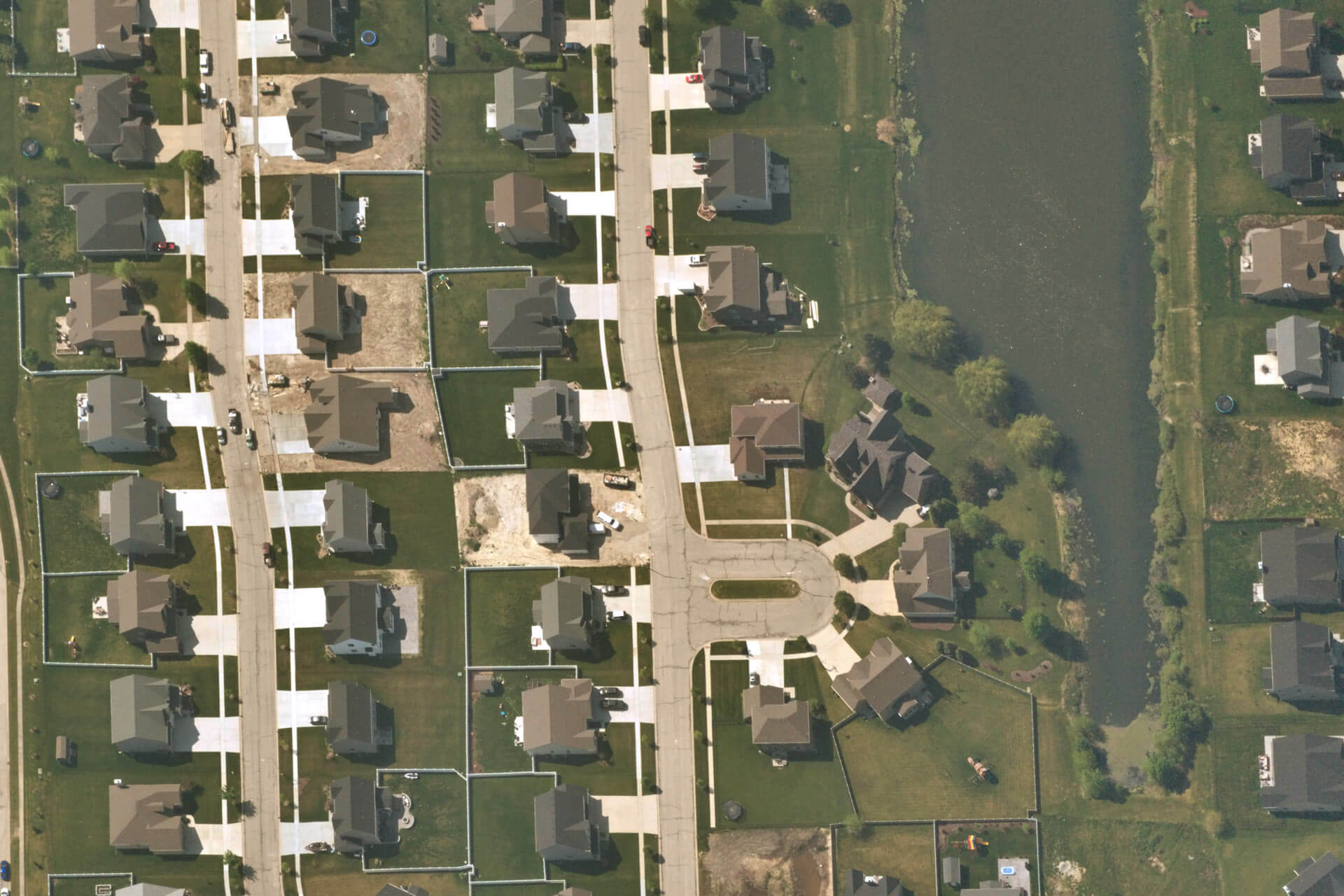
Near Space Labs capture of rural neighborhood in Texas. February 5, 2022.
Satellites, airplanes, and drones are able to cover some of the above requirements, but none can offer all three. Stratospheric remote sensing allows more capabilities, with the ability to collect sub-daily imagery and with 10 cm resolution.
While high-quality Earth imagery is essential to capture how our cities are changing, it is just one part of the solution. Leveraging and aligning multiple geospatial data sources together is how people combined with AI and machine learning will build the most reliable and accurate solutions. Integrating visual band data together with lidar data to build 3D models, or SWIR sensors to track emissions in highly volatile environments, or infrastructure maps to understand how cities are operating above and below ground, will help paint a holistic picture of how the world is changing and guide decision-makers to create scalable solutions to protect and build sustainable living. With many data sources involved, the quality and accuracy of each is essential to build powerful change detection models.
To conclude, geospatial data via remote sensing is empowering the creation of digital and smart cities, helps identify process improvements such as city planning and development, and enables businesses, governments, and planners to build innovative and scalable solutions. With high-quality and frequent data of the Earth, we can enhance our AI and machine learning models and technology solutions to build smarter, more efficient, and more sustainable communities and cities.
For any questions about how stratospheric imagery can help track changes in your area, please contact us here.


