Near Space Labs Brings Highest Resolution Geospatial Imagery Down to Lowest Cost
Affordable price point broadens access to high-quality data needed to sharpen decisions about our planet delivered via zero-emission platform.
February 3, 2022 – Brooklyn, New York – Near Space Labs, the cutting-edge geospatial intelligence and Earth observation company, today announced the launch of its 10 cm per pixel Earth imagery resolution. This highly detailed imagery will be offered at the same affordable price as Near Space Labs’ 30 cm imagery, providing three times the resolution for no additional charge to power a wide range of industries such as city planning, conservation, government insurance, mobility, and more. Near Space Labs increases access to relevant, timely, and wide-scale information about the Earth to everyone who needs it, with no trade offs between resolution, frequency, and cost.
“We all know knowledge is power, but for years, Earth imagery at the 10 cm level has been limited to a select few who can afford to task a plane or satellite. Additionally, satellites provide low resolution imagery and are inflexible, while planes require perfect weather conditions and emit massive amounts of greenhouse gasses. Without improving our options and expanding access to this information, we’re collectively operating in the dark,” said Rema Matevosyan, Co-Founder and CEO of Near Space Labs. “We founded Near Space Labs because we believe high-quality geospatial imagery is key to unlocking new solutions to humanity’s biggest challenges and should be available to all of the world’s brightest minds – without producing environmental waste.”
Near Space Labs’ autonomous wind-powered high altitude platforms, called Swiftys, make frequent flights in the stratosphere and capture 400-1,000 square km of imagery per flight (the equivalent of approximately 187,000 football fields). Swiftys are easy to deploy, wind and software powered, and zero-emission.
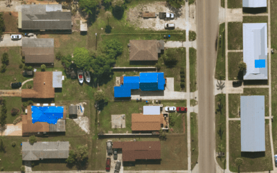
The Swiftys collect optical imagery data as they fly over cities and other strategic areas. The technology is capable of detecting a variety of details from above, including building characteristics, road conditions, roofing details, vegetation, and wildlife – all the way down to a soccer ball on the ground. Near Space Labs’ images are incredibly flexible and can be used across many industries and use cases, including:
- City planners can see potholes or road conditions and track urban sprawl to improve city and suburban development.
- Conservation groups can track and count wildlife populations and see details of vegetation to monitor crop health.
- Insurance companies can evaluate weather damage, visualize roofing materials, or underwrite remotely.
- Mobility and transportation companies can see road and highway conditions at scale to create better maps and build charging stations for autonomous and electric vehicles.
“Near Space Labs’ new imaging capabilities are a game-changer. The combination of high-resolution, high-frequency imagery at affordable rates has simply not been available before,” said John-Isaac Clark, CEO of Arturo, an AI-powered platform that derives property insights and predictive analytics from aerial and satellite imagery. “At Arturo, by applying our machine learning models to these new images, we’re able to derive better actionable intelligence than we have before. And at the end of the day, it’s our clients who benefit: they have better knowledge, which leads to better decisions. With more businesses like ours able to access this kind of data, it will open up countless possibilities for our customers and many others.”
Today’s news follows Near Space’s $13M Series A funding round from investors including Crosslink Capital, Leadout Capital, Toyota Ventures, and Wireframe Ventures. This investment helps accelerate the company’s geographic expansion, drive team growth, and further the development of new technologies to meet towering consumer demand heading into 2022.
Near Space Labs’ 10 cm geospatial imagery resolution is available now. The company will also be making free sample data available in the coming weeks. To learn more, sign up here.
For more about Near Space Labs, visit: https://nearspacelabs.com/.
About Near Space Labs
Near Space Labs is a cutting-edge Earth observation company on a mission to provide universal access to high-quality information about our rapidly changing planet. Co-Founded by CEO Rema Matevosyan, CTO Dr. Ignasi Lluch, and Chief Engineer Dr. Albert Caubet, Near Space provides timely, wide-scale, commercially available imagery with the largest zero-emission balloon fleet in the stratosphere. Near Space Labs is revolutionizing the way that businesses, communities, municipalities and researchers gather data that can help solve some of the world’s biggest problems.
Press Contact
Kate Helete
nearspace@thekeypr.com
805-458-5093